Bangalore - Traffic
Traffic is probably the most popular subject of discussion in Bengaluru. Language of rage, frustration, surprises and disappointments is universal, but attempts to collect menanigful information and data and analyze them are far and few.
This Gyan page holds together informative Praja posts on Bengaluru Traffic. This is the "book" where posts with summary, detailed analysis or statistics on traffic, congestion, violations, enforcement etc can be grouped together and categorized for easy reading.
Bengaluru: Traffic congestion
1. Overview
2. History
3. Data
4. Solutions
5. Examples
6. References
BBMP and Road Widening
Most aware citizens say that widening roads to fight traffic congestion is like buying larger clothes to fight obesity. BBMP and some others feel that some arterial roads are choked, and road widening is a must.
Such direct focus on roads, and so little on mobility has been a problem with Bangalore's planners for a decade now. But its only in early 2010, when a large road widening scheme from BBMP threatened to touch thousands of private properties that the debate has hit common citizens of Bengaluru.
Scientifically speaking, city roads needs consistent width - 4 lanes would do just fine - in corridors, better management of stopping and parking along the ribbons of corridors, width for pedestrians to keep them off the tar, and improvement at junctions to manage the flow.
At times, road widening is also discussed in the context of "Signal Free Corridors". But going by BBMP's plans, it is not clear if all road widening work has been planned as part of select few "signal free corridors". Even there, feasibility of creating a dozen signal free corridors inside the city area is itself a heavily debated subject.
How Wide is Wide?

Nomatter however the road is wide, there is always traffic jams. Still BBMP seems to have not analyzed the problem and expanding the roads by cutting trees and reducing pavements has become its endless project. Today morning I saw trees on the Maharani's College Road while getting down the Anand Rao circle which were 'alive' from 100s of years being cut to widen further. Already the road is 1 way and it is a 4 lane road. Why to loose our greenery unnecessarily. Also the pavements were narrowed still further. We all know, how matter the road is wide, still traffic will not reduce. Length of the jam decreases and width increases. We have seen the examples of Bangkok, as well as we have seen the roads of California. Its all so wide still there are lots of delays in traffic. Why to loose our precious trees which are seniors in terms of age for a foolish act of road widening which we all know is not going to give us any solution. Loosing the tree for a Metro Rail / Mono Rail is OK since it is minimal as well as it is definitely give us a solution. Still, alternative routes should be taken wherever possible to avoid tree cutting such as the case in Nanda Road. I think the act of BBMP to cut trees to widen road is just 'ridiculous'. What is our environmental agency 'Hasiru Usiru' doing?
Maharajah's 13 acre donation to Bangalore


I guess the Grand Poobah has consented to giving some of his palace land for greater good so we can now get back to solving the making-cauvery-junction-signal-free riddle from square one. Hope they will build a regular flyover now and close the current magic box for good.
So the chicken neck on Bellary Road is expected to be gone in 3 months. I am confident BBMP's road engineering techniques will ensure we will have the same jams we are having now as it will just be a sea of asphalt with no pedestrian sidewalk and road markings.
Mayor shelves road widening
Just happened to come across this news from couple of weeks ago. BBMP Mayor finally shelves the road widening plans. Temporarily? Your guess is as good as mine.
Addressing a press conference Mr Nataraj said BBMP and property owners themselves were free to erase the red markings on buildings and houses in the core areas of the city for the time being. “Roads will be widened only in the newly added areas and where people themselves feel it is neccessary,” he said.
....... the mayor said he had written to the state government to earmark 20 per cent of BDA sites for a rehabilitation package for those who stood to lose 90 % of their property.
“If the government fails to respond positively road widening will be aborted,” he promised
So, does this mean they will proceed if government agrees to earmark BDA sites? What a contradiction. Our leaders have become the masters of saying both yes and no in the same breath, and we have become the masters of beliving what they say.
He also revealed that a scientific survey would be conducted from September onwards to zero in on the roads Whether we believe or not, we should at least put pressure on them to follow their words.
that need to be widened. After the survey, members of Resident Welfare Associations (RWA) and others would be consulted before the work began.
“Only If 90 % of the people agree on widening a particular stretch, will it be taken up,” Mr Nataraj added.
Mysore Road - Choke Point 1 - Guddadahalli Junction
The BBMP has propsed that the stretch from Sirsi Circle to Gali Anjaneya Temple on Mysore Road be widened. This involves chopping trees all along the stretch. These are already well-known plans from the news reports and praja discussions. There are a couple of estimates on the number of trees to be chopped some saying 50 and some 100+. But, lets not be get into the numbers. Whats important is to find ways to solve the bottleneck without chopping the trees, if any available.
Mysore Road starts from KR Market. Vehicles zip across from Town hall on the flyover for about 2.5 kms, pass over the Sirsi Circle, and get struck at the ramp of the flyover. Why ? There is a choke point immediately after the flyover (about 150mts away).
The picture above shows the road plan to the west of Sirsi Circle. The Flyover bring in two lanes of traffic, the surface level slip road from Sirsi Circle brings another two lanes of traffic and there is two more lanes of traffic joining the 'intersection' from Chamarajapet, through the Albert Victor Road. That is six lanes of traffic merging into two lanes in space of about 100 mts. Add to this, there is a right turn into Old Guddadahalli immediately after, and hence the merged traffic should also re-align lanes so enable vehicles from AV Road to enter Guddadahalli Road.
There is a traffic signal installed about 200 mts from the end of flyover, only to enable the right turn into Guddadahalli. This means the traffic on the other side of the road - from Bapujinagar to Sirsi Circle/Flyover - gets stalled at the si. gnal. This creates long jams on both sides of the road. Peaks hours are terribly bad, Saturdays are worse!!
The solution to this issue lies in widening the junction to accomodate more vehicles. Long stretches of roads need not be widened for smoother traffic flow. Its time now for BBMP to widen junctions, as against road widening. This post has a plan to fasten the exit from this intersection.
Firstly, there are two small streches to be widened (marked in the picture above). On the northern side, the strech from DHL office to the burial ground - about 200mts - has to be widened. On the other side of Mysore Road, the stretch from the end of Albert Victor road to the IOC petrol bunk (immediately after the present signal) has to be widened. This will mean loss of only 3 trees each on either side( two more have already been chopped off!!).
Another important change required at the junction is to remove the traffic signal. This can be achieved by a simple 7mts (two lane) magic box on the northern half of the Guddahalli-Mysore road junction. Illustration below.
This will assure uninterruped movement on the nothern side of the road - for vehicles from Bapujinagar side to Sirsi Circle. Post widening, there will be enough width (single lane)on the surface level for any vehicles from Bapujinagar to turn left into Guddadahalli.
For vehicles from Ch'pet or Sirsi Circle, removal of the signal will mean uninterrupted right turn into Guddadahalli. U-turns for the same vehicles will also become more faster, since they do not have to compete for the road space with the vehicles in other direction.
These two simple steps will help ensure fast movement of traffic, at only about 10% of the 17-crore budgeted for widening the road.
There are two further choke points - one near the Shell petrol bunk and another close to the Gali Anjaneya Temple. I will write on these two separately.
Road Widening Hits Road Block - PIL
Karnataka High Court admits PIL against Road Widening Projects in Bangalore
Issues emergent notices to Respondents
Mr. Chief Justice Cyriac Joseph and Mr. Justice A. N. Venugopal Gowda, constituting the Division Bench of the Hon'ble High Court of Karnataka, today admitted a Public Interest Litigation (PIL) filed by Environment Support Group and others against the ongoing irrational road widening projects of the Bruhat Bangalore Mahanagara Palike (BBMP – Corporation of the City of Greater Bangalore). Appreciating the urgency for considering the need to protect avenue trees from needless felling and safeguarding various rights and priveleges of pedestrians, street vendors, etc., the Hon'ble Judges issued emergent notices to the Respondents while also allowing for serving of hand summons.
The PIL challenges BBMP's ongoing project of widening 91 roads (a number likely to increase) in Bangalore, running into a length of about 400 kms. across the length and breadth of the old city areas. This mega project is predicated on the premise that it would result in improved flow of traffic and reduce congestion. However, no evidence has been presented to prove that the result of widening would actually achieve these objectives. In contrast to the approach adopted by BBMP, experience from densely populated and leading cities from across the world prove that widening of roads is not the solution for easing traffic congestion. Instead intelligent design approaches, responsive (rather than reactionary) traffic management, enhancement of public transport, improvement in pedestrian zones, protection of livelihoods of vendors, and discouraging personalised modes of transport have successfully addressed the most serious traffic congestion problems of mega cities. Such approaches have also enabled the protection of cultural heritage, public spaces and urban greenery, significantly enhancing the environmental quality of urban areas.
The PIL makes a strong case against tree felling as the first step to road widening by demonstrating that the work undertaken by BBMP in several roads has proved unsuccessful in reducing traffic congestion. The Petitioners submit that the actions of the Tree Officer in authorising the felling of hundreds of avenue trees violate various provisions of the Karnataka Preservation of Trees Act, and is admittedly an action taken under duress. In most cases where hundreds of really old avenue trees have been felled, the stated object of widening has not been achieved even after years, as various utilities have not shifted out of the proposed right of way, or such spaces have been encroached by places of worship.
The PIL relies heavily on the National Policy on Urban Street Vendors, the National Urban Transport Policy and a variety of circulars issued by the Union Urban Development Secretary that argue for a rational and intelligent approach to managing congestion in urban areas. In particular, it makes a case that the object of all travel is to ensure people move across cities in safety and comfort, thus necessitating privileges to pedestrian movement, non-motorised forms of transport and public transport. Contrarily, the BBMP's approach seems to arrogate a right for the private motor car over all other modes of travel, thereby extinguishing many fundamental rights, while also exposing the public at large to great discomfort and even harm.
The PIL presents a variety of evidence to argue that the road widening programme is illegal as it has skirted fundamental public consultation processes required per the Karnataka Town and Country Planning Act. In addition the draft Comprehensive Development Plan -2005 (CDP) of Bangalore Development Authority, defining land use of the city, did not contain any proposal for widening roads on such a grand scale. Surprisingly, the final CDP – 2007 introduced plans for most inner city roads to be widened without in any manner informing or involving the public, an action that is patently illegal.
The PIL is a result of a long and deliberate series of proactive steps taken by the Petitioners along with Hasiru Usiru, a network of concerned groups and individuals in Bangalore. The Petitioners draw attention to the ruling of the Hon'ble High Court of Karnataka in 2005 (WP No. 14104/2005) in which the Government was directed to involve the public in decisions relating to road widening and tree felling. It is submitted that despite exhaustive efforts on the part of the Petitioners and Hasiru Usiru urging the Government and its agencies to engage with the public in evolving such schemes, the current road widening project has been rushed through disregarding the directions of the Hon'ble Court. In this context, it is prayed that the Hon'ble Court be pleased to strike down the road widening proposals, and the consequent tree felling orders. In addition, it is prayed that the Govenment be directed to evolve rational road development proposals that met with the highest standards of law, policy and urban planning.
The petitioners Environment Support Group and CIVIC Bangalore were represented by Advocate Mr. Sunil Dutt Yadav and Mr. Leo F. Saldanha, Coordinator, Environment Support Group, appeared in person. A copy of the PIL is accessible online on ESG website.
Road Widening hits a road block?
Today’s Sunday times had the head line on road widening ahead of Food Ball news for a change.
Your house cannot be taken forcibly under TDR.
“As per the rules, BBMP can take up road widening only under the Transferable Developments Rights Scheme (TDR). If the private property owner does not cooperate in giving away his land for road widening the process cannot be taken up legally”
The only option for BBMP is to forcibly acquire the property by paying current market rate under Karnataka land acquisition act. What then was the relevance of BBMP TDR in the first place? Was it to take away the property without proper compensation?
Road Widening in Bangalore - City convention on 4th July

Hi All,
"Save Bangalore committe" has taken up for a city convention about road widening in Bangalore.
Thought of sharing the information with all of you. Please go through the attachment for the details.
Thanks,
Manoj
Hi All,
"Save Bangalore committe" has taken up for a city convention about road widening in Bangalore.
Thought of sharing the information with all of you. Please go through the attachment for the details.
Thanks,
Manoj
| Attachment | Size |
|---|---|
| road widening BSS.pdf | 335.41 KB |
Road widening - Futility & Alternatives
Road widening - Futility & Alternatives
Background
BBMP listed 217 roads to be widened. This has caused much worry among citizens as it entails widespread destruction of both greenery & property. Why do so many roads need to be widened? What are the characteristics of congestion on this road? What are the traffic patterns on these roads? Should congestion be reduced by widening or by any other strategy? Are already widened roads being used efficiently? Have we addressed the efficiency of current road widths? This paper attempts to focus on the efficiency of current available road space and put widening into perspective as a long term strategy.
Futility
The simple truth is that building more highways and widening existing roads, almost always motivated by concern over traffic, does nothing to reduce traffic. In the long run, in fact, it increases traffic.
A recent University of California at Berkeley study covering thirty California counties between 1973 and 1990 found that, for every 10 percent increase in roadway capacity, traffic increased 9 percent within four years' time1.
Yet another study, on why building wider roads isn’t the answer, in analyzing sixty road closures worldwide, found that 20 percent to 60 percent of driving trips disappeared rather than materializing elsewhere2.
USA Today published the following report on Atlanta: "For years, Atlanta tried to ward off traffic problems by building more miles of highways per capita than any other urban area except Kansas City…As a result of the area's sprawl, Atlantans now drive an average of 35 miles a day, more than residents of any other city."· This phenomenon, which is now well known to those members of the transportation industry who wish to acknowledge it, has come to be called induced traffic.
The phenomenon of induced traffic works in reverse as well. When New York's West Side Highway collapsed in 1973, an NYDOT study showed that 93 percent of the car trips lost did not reappear elsewhere; people simply stopped driving.
This condition is best explained by what specialists call latent demand. Since the real constraint on driving is traffic, not cost, people are always ready to make more trips when the traffic goes away. The number of latent trips is huge--perhaps 30 percent of existing traffic. Because of latent demand, adding lanes is futile, since drivers are already poised to use them up.
Automobile use is the intelligent choice for most people because it is what economists refer to as a "free good": the consumer pays only a fraction of its true cost. We learn in first-year economics what happens when products or services become "free" goods. The market functions chaotically; demand goes through the roof. In most cities, parking spaces, roads and freeways are free goods. Local government services to the motorist and to the trucking industry--traffic engineering, traffic control, traffic lights, police and fire protection, street repair and maintenance--are all free goods.3
A piece of statistic from the Mumbai Traffic Police web site illustrates the magnitude of the problem: While length of roads in Mumbai increased two times between 1951 and 2007, the population increased 5.4 times and the number of vehicles a whopping 43 times.
Another way of widening or adding lanes is to build elevated roads. Essentially it is another way to add bandwidth which is similarly destructive. In fact most countries are today opting to pull down the elevated highways they have built, following are some examples
|
Elevated roads already removed |
Elevated roads being removed |
Removals proposed by citizens |
|
Portland, OR: Harbor Drive |
Rochester, NY, Innerloop |
Baltimore, MD, Jones Falls Expressway |
|
San Francisco, CA: Embarcadero Freeway |
Trenton, NJ, Route 29 |
Seattle, WA, Alaska Way Viaduct |
|
San Francisco, CA: Central Freeway |
Akron, OH, Innerbelt |
Bronx, NY, Sheridan Expressway |
|
Milwaukee, WI: Park East Freeway |
Washington, DC, Whitehurst Freeway |
Buffalo, NY, Route 5 |
|
Toronto, Ontario: Gardiner Expressway |
Cleveland, OH, Shoreway |
Hartford, CT, Aetna Viaduct |
|
New York, NY: West Side Highway |
New Orleans, LA, Claiborne Expressway |
Louisville, KY, Interstate 64 |
|
Niagara Falls, NY: Robert Moses Parkway |
Nashville, TN, Downtown Loop |
Portland, OR, I-5 |
|
Boston, MA: Interstate 93 (moved underground) |
New Haven, CT, Route 34 Connector |
Chicago, IL, Lakeshore Drive |
|
Paris, France: Pompidou Expressway |
Montreal, Quebec, Bonaventure Expressway |
|
|
Seoul, South Korea: Cheonggye Freeway |
Tokyo, Japan, Metropolitan Expressway |
|
|
Sydney, Australia, Cahill Expressway: (Moving to underground) |
What do we want?
The important question is not how many lanes must be built to ease congestion but how many lanes of congestion would we want? Do we favor four lanes of bumper-to-bumper traffic at rush hour, or sixteen? So what are we trying to do with these road widening projects? Are we looking to loosen the belt to accommodate the flab or do we have a plan in place to address the bulge?
There will pretty much always be a latent demand for more driving. Much of that demand is discouraged or diverted by congestion. Much of the discouragement goes away when the road is less congested.
The key is not to strive to reduce congestion. A healthy city must provide alternatives to congestion: convenient bicycling/walking/transit, compact development, pricing roads/parking, etc. And all of these healthy alternatives are much more likely, politically, when there is a lot of congestion. It is no coincidence that those cities with the worst congestion have the best transit.4
Alternatives
Many cities have set modal share targets for balanced and sustainable transport modes, particularly 30% of non-motorized (cycling and walking) and 30% of public transport. A larger plan on limiting road facilities has to take into account provisions for public transport & NMT as well. The modal share of NMT is pretty abysmal for a populated country like ours. Today no road widening includes a default NMT/PT lanes. If transport involves moving humans from place A to place B in the most sustainable way we are exactly not doing that.
In the short term a lot of wastage in built out bandwidth is seen. This leads to traffic jams in addition to volume induced congestion. The effect of this suboptimal usage of bandwidth compounds the feeling of congestion and hence making us feel it is much worse than it actually is
Using existing road width efficiently
In India specifically, today there are many causes of misuse of the current bandwidth. The 3 E’s of traffic namely Engineering, Education & Enforcement are broken. This contributes to traffic jams which take the form of abrupt slowing down of traffic just to sort themselves out on the streets hence causing backups taking a while to unclog. Lets look at the following factors which slow down traffic
Bad Engineering
Inconsistent Lanes – Most lane markings on the roads are ill defined. The lane sizes vary anywhere from 3.5 to 4 meters or more in most stretches and are not consistent all along. Effects of this are merging, severe slowdown of movement and lower than average speed resulting from encroachment into each other’s lanes & fight over road space. This is undesirable as the road engineers have lost control of the traffic & have left the road users to define the space & fend for themselves.
The lane widths need to be tighter at 3.3 meters & consistent all along. Especially the outer lanes, toward the curb, tend to hold all excess road space as a part of the lane. These extra space needs to be blocked for vehicular access by turning them into well marked space for parking or for pedestrians/NMT. The lanes are also discontinuous in most parts. All lanes need to have continuity and any break or merge needs to be properly marked with clear advanced instructions in the form of well-placed signboards
AdHoc Parking – Free parking as currently practiced in the city is a major contributor to this congestion in fact it has been observed in places like palace road that roads have been widened only to accommodate parking. If we have to make any impact in managing traffic we need to impose true cost of parking on the users. These free goods only compound the inducements already provided by widening.
Poor Quality roads – World Bank studies have confirmed that the economic losses due to insufficient pavement thickness and poor riding quality is estimated to be of the order of Rs. 30000 crores (300 billion) per annum. This is only the vehicular operation cost and does not include cost of traffic jams caused due to slowdowns & congestions It is clear that interruptions like potholes on the road slow down vehicles causes a backup & jams. Ensuring unscientific speed breakers & potholes are removed from the road
Insufficient traffic Channelizing – Traffic channelizing is the essence of traffic engineering. It is essential to tackle junctions & merges in such a way that there are no impediments to the speed of travel. The average speed of travel can be increased by keeping traffic flowing smoother at lower speed than by having a high speed corridor with many interruptions which bring down the average speed. Junction optimization with synchronized signaling & vehicle actuated traffic lights can cut down on travel time significantly on key corridors
Bad driver Education
While Engineering lays down the standard for how the traffic should flow it is entirely useless of the drivers who use them are not aware of the appropriate driving practices. It has been found that drivers in the cities are from a lower socio economic background and arrive from places outside the city which do not have a high standard of road infrastructure. It is important then that these people are trained & certified/recertified on the upgraded infrastructure separately. A written & driving test in an RTO office should be made mandatory for people who have obtained license from outside the city. Transport department officials, Police & training institutes should have their staff certified by the Engineering team for proper usage of infrastructure. The transport department needs to also ensure basic vehicle conditions like tail lights & mirrors are in use and not broken or unusable.
Bad Enforcement
Enforcement in India is characterized by low fines leading to callousness by the vehicle user. Fines need to be increased to make it a viable deterrent & respect needs to be inculcated for Pedestrians & Bicyclists. Transportation is heavily influenced by peer behavior as it is a social exercise. If people notice some people getting away with violations they are encouraged to do the same. Hence visible policing is important to set example and induce proper driving behavior.
Prioritization
Prioritizing road widening projects that are already on stream needs to be completed, their results studied before moving forward and starting other similar projects. Corridors need to have a meaning and not every road which has traffic becomes a corridor. Certain so called corridors like Sankey road already have alternate roads under widening mode. Redundant corridors should not be built as it dilutes the purpose and focus of corridors
Measurement of traffic also has to be done using PCE units rather than PCU units as the weightage for heterogeneous traffic has to be considered. Passenger Car Equivalent (PCE) is essentially the impact that a mode of transport has on traffic variables (such as headway, speed, density) compared to a single car. Typical values of PCE (or PCU) are:
- private car (including taxis or pick-up) 1
- motorcycle 0.5
- bicycle 0.2
- horse drawn vehicle 4
- bus, tractor, truck 3.5
Congestion charging
Congestion pricing or congestion charges is a system of surcharging users of a transport network in periods of peak demand to reduce traffic congestion. Traffic in central London post congestion charging went down by about 21 per cent, and traffic speeds went up by about 10%. reports from the cities that have implemented congestion pricing schemes show traffic volume reductions from 10% to 30% as well as reduced air pollution. Singapore ERP pricing has been effective in maintaining an optimal speed range of 45 to 65 km/h for expressways and 20 to 30 km/h for arterial roads.5
References
1 Carol Jouzatis. "39 Million People Work, Live Outside City Centers." USA Today, November 4, 1997: 1A-2A. As a result of its massive highway construction, the Atlanta area is "one of the nation's worst violators of Federal standards for ground-level ozone, with most of the problem caused by motor-vehicle emissions" (Kevin Sack. "Governor Proposes Remedy for Atlanta Sprawl." The New York Times, January 26, 1999: A14).
2 Jill Kruse. "Remove It and They Will Disappear: Why Building New Roads Isn't Always the Answer." Surface Transportation Policy Project Progress VII:2 (March 1998): 5, 7.
3 Stanley Hart and Alvin Spivak. The Elephant in the Bedroom: Automobile Dependence and Denial; Impacts on the Economy and Environment. Pasadena, Calif.: New Paradigm Books, 1993, 122.
4 An excerpt from Suburban Nation: The Rise of Sprawl and the Decline of the American Dream by Andres Duany, Elizabeth Plater-Zyberk, and Jeff Speck North Point Press, 2000, pp. 88-94.
5 Wikipedia
Save these trees - road widening?
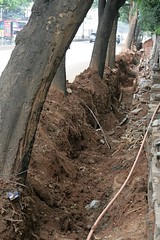
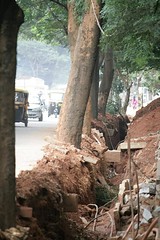
BBMP/BWSSB are at it again. I am surprised at the ease with which they go about cutting the trees.
This time it is the stretch of road between BDA junction and Cavery Theater junction (New Airport Road). Some one really very creative is at work here - they are finding new innovative ways to cut down trees and this time BWSSB has chipped in to help them.
In this particular case - BWSSB dug deep trenches just next to the trees (they are laying a pipe line). With in days most of the trees tilted dangerously towards the trench. A couple of days latter all these trees were cut down - may be citing treat to life and property. Surprise surprise, a few days latter, the foot paths are decreased and work is on to increase the width of the road - all this natak for a few extra feet of road (for a road which is already wide enough). Most of these tress were atleast 50-60 years old.
Anyways this thing has not stopped yet. This "Kill Tree" operation is on in full swing. BWSSB has gone ahead and started digging along the entire stretch. It is only a matter of days before the trees on the whole stretch will either be cut off or they will fall on their own.
The next picture shows the extent to which these trees have tilted. All that is needed to complete the "Kill Tree" operation is just a few strong winds.
Notice the deep trenches and the tilting of the trees in these pictures
I am not anti-development. BWSSB i am sure had valid reasons to put the pipe line. But what surprises me is, why they choose this side of the road? The other side has relatively (alomost none) less no of trees. Yes the would have had to dig the road at one or two places - was the cost of relaying the roads more than the life of these well grown 20-30 trees. BBMP seams to have messed up their priorities - completely.
The damage is already done. But certainly everything is not lost. Can we force BWSSB to stop this digging? I am hoping with some support structure these trees can still be saved.
I tried calling Mr S Shekar - Deputy Conservator of Forest (BBMP) on 9739042158, with out any luck. There is also a tree officer in BBMP - he can be reached on 22485317. Prajagale, please spare a few minutes and each one of you call this person to force him to do an inspection of this stretch. Also spread the word :) I am hoping against hope to save these trees.
Rithesh
Prajasevaka :)
Bangalore and Signal Free Corridors
Public transport die hards don't want any of this. Car lovers want them. But many believe that some solution is required in Bangalore to improve radial connectivity across ends of Outer Ring Road.
- BBMP has been trying to improve radial connectivity by widening some corridors, and planning more flyovers etc at busy signals.
- BBMP has tried doing this on Belary Road via Magic Boxes.
- Some people have proposed tunnel roads to connect CBD with Outer areas.
- BDA is converting Outer Ring Road to a signal free corridor
- CTTP 2007 had proposed long elevated roads above 4 key radial corridors.
Let us outline detailed posts on the subject under this book. This is a wiki post anyway, so if anyone wants to add more to this page itself, just edit it instead of adding comments.
"Signal free" Hosur Road: opportunity or nightmare?
Just caught this in the news; BBMP's plans to convert Hosur road to a Bellary road like "signal free" stretch (read more here).
This is another series of traffic engineering nightmares just waiting to happen (narrow underpasses, plain bad design, non-existent pedestrian infrastructure). Ironically, they actually have cited Bellary Road as the model to emulate. There must be some way to get in on this and at least attempt to get things done more holistically. RTI the design plans? Another meet with BBMP? Two things that I could immediately think of:
- Given BMTC's "Kendriya Sarige" plan, isn't there some way we can get the BMTC and BBMP to work together on this one and create a (curbside?) bus lane. If it works, we'll have a bus lane from Vellara junction to CSB. It's ambitious I know, but it's worth a shot.
- Integrate creation of pedestrian infrastructure in all plans (pedestrian subways, broader pavements, guard rails)
Thoughts? Ideas?
transmogrifier
BBMP has grand plans for the city
The transport minister has come out with a mega proposal for Bangalore.
http://www.deccanherald.com/content/23637/mega-revamp-plan-city.html
Some highlights -
"With a massive financial outlay of Rs 22,000 crore, the Bruhat Bangalore Mahanagara Palike (BBMP) plans to drastically change the face of the City’s roads, drains and lakes in three years."
"To make 12 key corridors signal-free, the plan is to equip over 100 junctions with grade separators. The total road length covered under this project will be 122 km, a network connecting the Central Business District (CBD) with Outer Ring Road and Radial Roads."
"Another important proposal is the construction of three elevated corridors, in the City’s north, south and east to decongest traffic. The south corridor will run from Vellara junction to Silk Board, the north corridor from Minsk Square to Hebbal flyover and the east corridor from Vellara junction to Kundanahalli junction."
Some questions and I think we should try and meet Ashwin Mahesh as soon as possible
a. Are they planning to demolish the current magic boxes between Hebbal and High Grounds to construct the elevated corridor?
b. The south elevated corridor and the east elevated corridor both end at Vellara junction. How are the roads leading out of this junction - Richmond Road towards Richmond Circle and Brigade Road/Museum Road going to handle this flood of vehicles?
c. Do roads also include sidewalks as part of them?
d. Does this interfere with Phase 2 of the Metro which supposedly will connect Yelahanka with E-City. Where will the viaducts for the Metro come up?
e. Given BBMP's track record of finishing grade separators, what is the execution plan that will enable this to be finished in 3 years. For the record - the 15th Cross underpass that was to have been completed in March 2009 is still not finished and this is on the ORR.
Srivathsa
Elevated Corridors - green light
Source Deccan Herald, CM Gets Cracking on City's Woes: "Yeddyurappa showed the green signal to BBMP to take up two elevated corridor projects: the 16-km North-South corridor connecting Hebbal to Madivala through Minsk Square and Vellara junction and the 12-km Bangalore East corridor connecting Kodihalli and Kundalahalli through Vellara junction..."
More on DH: Elevated corridor projects to ease traffic : "... The project has been conceived in the wake increasing traffic density in North due to International Airport at Devanahalli ... detail project report is yet to be prepared to identify location of loops along the corridor. ... Palike has found the project is the only way to provide signal-free movement of traffic between South and North. As the road will be built over existing roads the project does not require land except around Vellara Junction. The road covers Sankey Road, Bellary Road up to Hebbal ... Swiss Challenge method ... IDEB has taken up the challenge. ... already submitted technical proposal, which is being studied by the Palike... project is expected to begin in 2009 September... Yeddyurappa said the proposed project solves major traffic problems of the city."
From The Hindu: Focus on Infrastructure Development : "Yeddyurappa on Tuesday announced the construction of two high speed corridors — Hebbal to Madiwala (16 km) and Kodihalli to Kundalahalli (12 km) — to enable fast motor traffic movement in Bangalore. ... apart from the two ... corridors a section of the outer ring road, Central Silk Board Junction to Bellary Road Intersection, would be made traffic signal-free ..."
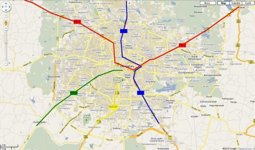
Find the bigger picture, covering all currently porposed elevated roads of Bangalore here - Bangalore Elevated Roads.
Elevated Inner Core Ring Road - whats up?
Remember the Inner Core Ring Road (ICRR) project? Find some documents here in case you need to jog your memory. BBMP and newspapers haven't talked much about it lately, and then The Hindu carried this piece (steel structures favoured for ring road) a few days ago.
There was one thing that struck me as odd in that news peice. Chief Engineer (Infrastructure) of the Bangalore Mahanagara Palike is advocating use of steel structures to build the expressway and is also dreaming up a 3 level road:
"it could have three levels for vehicles to travel — the existing ground level, one for two-wheelers and another for four-wheelers, he said."
But then, two execution models are suggested:
"The project could be proposed under Jawaharlal Nehru National Urban Renewal Mission or be given out to private companies on a Build Own Operate Transfer basis."
BBMP's engineers are clearly thinking design, that probably tells us we shouldn't assume that ICRR will be developed on a BOOT basis. Is BBMP thinking of doing the project itself?
Please. No! BBMP, you have zero experience building and managing such roads. Don't think of doing it yourself.
KR Circle to be Signal free
Read this in today's paper.
http://www.hindu.com/2009/03/30/stories/2009033059820400.htm
"Bangalore: Bangalore will soon have its widest magic box underpass for vehicular movement at K.R. Circle.
The underpass, to be built across the road leading into Cubbon Park at K.R. Circle, will have a width of seven metres. It will connect Ambedkar Veedhi with Nrupatunga Road and make the junction signal-free."
Anyone knows anything more about this grand plan? This is called kicking the can down the road. All the traffic piles up on Nrupathunga Road (near the signal at Hudson Church). Or do they plan another magic box so that this traffic keeps flowing? Imagine Cubbon park; it will become impossible to walk inside as traffic will flow non-stop. And it's not that all this will make car drivers more patient. They take uninterrupted travel as a birthright and BBMP panders to them.
Well managed signals can lead to smoother traffic flow. The problem with our traffic lights is that people don't wait in lines and in the correct lanes and hence traffic jams occur at the signals itself. This small fact seems lost on BBMP and its engineers. Any such structural intervention should follow detailed analysis.
How are pedestrians going to cross? There are colleges and plenty of government offices there. I plan to write to the ACP Traffic police and let's see how he responds.
Srivathsa
More signal free madness
More signal free madness from BBMP. And this is going to cost Rs.2500 crores. Saw this in bangalorebuzz.blogspot.com but could not source the newspaper.
http://bangalorebuzz.blogspot.com/
"Commuters who have to put up with tiresome waiting at traffic signals in the city, could be in for some relief.
The Bruhat Bengaluru Mahanagara Palike (BBMP) hopes to make 12 major corridors, including Cubbon Road and Rajkumar Road, signal-free for improved traffic flow in the city.
The initiative, which is likely to cost it Rs 2,500 crore, could help save vehicles travel time and fuel, and reduce noise and air pollution."
"The 12 corridors which will be made signal-free are the Dr Rajkumar Road from Yeshwanthpur Junction to Okalipuram (5 km), Chord Road, from Mysore Road Junction to CV Raman Road (10.5 km), Magadi Road, from Chord Road to Outer Ring Road (3.5 km), from Mysore Road Junction to Central Silk Board Junction (14.5 km), Central Silk Board Junction to Vellara Junction ( 6 km), Bannerghatta Road, from IIM-B to Wilson Garden (9.5 km), Vellara Junction to Whitefield via Varthur and HAL (13.5 km), Agara lake to Sirsi Circle via Lalbagh Fort Road (8.5 kms), City centre to Kengeri via Sirsi Circle (15.5 km), Yeshwanthpur industrial area to Hebbal, between NH 4 to NH 7 (6.5 km), Mekhri Circle to Benniganahalli via Jayamahal Road (12.5 km) and Cubbon Road to ORR via Kamaraj Road, Buddhavihar Road and Hennur Road (7 km)."
a. What e.g. happens at Vellara junction? what happens at Kamaraj Road/MG Road jn? All the traffic will pile up there as it happens today at Nrupathunga Road/KG Road jn.
b. Mysore Road to Silkboard - we are still stuck with incomplete underpasses at JP Nagar and Kadirenahalli.
c. Where does this leave the pedestrian? I have seen the plight of pedestrians trying to cross Bellary Road near HQ Command and just before Mekhri Circle.
As usual BBMP views our city as a network of roads and a thoroughfare with little regard for aesthetics. Just look at the Basaveshwara Circle or KR Circle today.
Srivathsa
Mysore road expansion - how can you remove the bottleneck?
Do planners in Bangalore realize that bottlenecks are the main source of traffic problems? It doesn't matter if you have a 5km long 8 lane road at the end of which has a bottleneck which reduces to 2 lanes.
It looks like that the Mysore road is going to be widened. The govt will end up spending crores of money and cause inconvenience to lot of riders during this widening spree. We'll also lose all the trees which so far have kept the Mysore road a complete canopy. But the Bapujinagar bridge is a huge bottleneck. If nothing is done to widen at this point, the whole effort is meaningless. Given that we have the Masjid and the GhaaLi Anjaneya temple on either side, we can imagine that this part of the road can never be widened.
Do the officials even think about this before going about doing their job of road widening?
Namma Raste - road use efficiency

Read in an email this morning that on 19th July 2008, a workshop on “Reclaiming Bangalore’s roads: Namma Raste” was jointly organized by Environment Support Group (ESG), CIVIC Bangalore and Alternative Law Forum at Vidyadeep, Ulsoor Road, Bangalore.
The context for this meeting was the PIL against BBMP over widening of 91 roads. Apparently, the claim is that the widening projects will increase average vehicle speeds from 8-10 km/hr to 40 km/hr (ref: material from ESG/HU - these should soon be up on ESG website, so I will save myself copy paste jobs here).
The workshop had over 90 participants, ranging from representatives of traders’ associations, resident association federations, and organizations working with the differently abled & for the urban poor, groups working on pedestrian rights, architects, schools, colleges and members of Hasiru Usiru.
I know there is a set of people who consider extreme environmental activism as anti-development. Put those biases aside for just a moment, and think about road widening efforts or flyovers that have come up in your area. Then, if you commute more than 5-6 km, tell us if your commute time has improved. Think and tell if there is enough proof that these projects help. Save for just a few flyovers, they don't!
I can give you an example from my area. My wife takes 45 mins today to do 9 km from Whitefield to IRR/Domlur area. It used to take asbout the same time (50 mins) to do Whitefield to Langford town two years ago. What has happened over last two years? Well, let me list them all
- Airport is gone, and hence a lot of vehicles.
- There is a new 6 lane railway overbridge at Marathahalli
- Marathahalli market area road has now been 'widened'.
- Airport road itself saw some limited 'widening'
- The road from Kundalahalli to Marathahalli too has been 'widened'
Despite all this, the speeds have reduced, ~ 20 kmph, to 10 kmph in this example. When you discuss this with self proclaimed urban development experts, the reason given is - there are more people and vehicles now.
Okay, alright. But isn't that the problem we should be attacking here!? More you build, more they come - that just can't be the excuse for misguided investments with undefined RoI (return on investment). The effort has to be to reduce usage of private vehicles for office commute. Investments have to be go towards managing whatever road resources we have. Past all that, we can look at adding more road area.
Lets put a number to the efficiency with which we use our road resources (I will post a whole lot of pictures to prove this point). Remember our talk of entropy, turbulence and all that? Every 200 meters, you either have
- encroached or missing pavement, leading to pedestrians on the road
- car parked on the arterial road (tons at Marathahalli)
- Some construction happening, with construction material spilling on to the road
- Bikers riding wrong side, autos criss crossing, blah blah blah - you know all this too well.
I would say that Bangalore's road use efficiency is probably about 40%. What I mean to say is that if the traffic and road space was managed to perfection, we can handle the same number of vehicles with 40% of road space.
Now, do widened roads add to this efficiency? 5% increase in road area gives you 2% increase in capacity to handle vehicles. That 2% increase in capacity to handle vehicles can come from efforts to increase road use efficiency itself. The question of course is -
- How I arrived at these numbers, plus
- would it cost less to increase road use efficiency.
Lets collaborate on a paper right here to arrive at rough numbers on road use efficiency. But I am willing to bet that #2 is true. Its not just that it will cost less to invest in increasing road use efficiency, but, this approach has better guarantee of success than investing in widening more roads and building more meaningless flyovers.
I have not rested my case yet. I need help to build that road use efficiency number :)
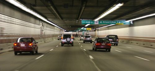
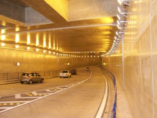
Rethinking road-widening - Tunnels?
One of the core infrastructural issues we are facing is an inability of our arterial roads and highways to provide rapid cross-town access. Globally, city and highway planners recognize and create different infrastructure for highways and city roads. See Dr. Joglekar’s posts here for a succinct description of this problem plaguing most Indian cities. A simple schematic (full size image here)and an inventory of city highways reveals the problem.
Thru Highways:
- NH7 (in blue)
- NH4 (in red)
Terminal Highways:
- NH-209 (in yellow)
- SH-17 (in green)
While the ORR and the planned PRR attempt to relieve through-traffic, these highways ironically remain some of the fastest cross-town routes. Recognizing this, infrastructural planners have expanded/widened roads leading into the city where land was available and have built (BETL, Mysore Rd flyover), are building (Nelamangala expressway) or planning to build (Balabrooie-Hebbal) long flyovers to ‘jump’ the bottlenecks. As we all know though, these just move the bottlenecks. And so, the ever-unpopular (and time-consuming) appropriation of massive amounts of land and road-widening is being touted as the panacea. There might be another way though.
An alternative
One option might involve reconnecting NH-4 and NH-7 using a belowground access-controlled (NOT signal-free) highway that cuts through the city and ensuring that NH-209 and SH-17 don’t ‘dump’ traffic in the middle of the city (full size image here).
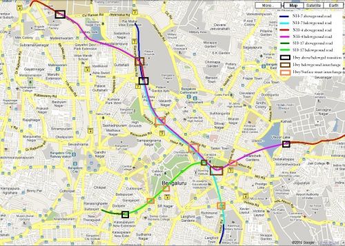
Specifically:
- Travelling south, NH-7 would move completely off the existing Bellary Rd after the Mekhri circle underpass moving onto Palace ground property (that might be available). At Cauvery theatre, it would join an emerging NH-4 and then ‘dive’ underground just before Palace Road ‘emerging’ near (or after) the Military school on Hosur Road.
- Traveling east, NH-4 would go underground near the IISc Gymkhana ground (potentially before the MS Ramaiah Rd intersection). It would emerge near Cauvery theatre (on Bellary Rd) and join NH-7. After ‘re-submerging’ near Palace Rd, it would travel along with NH-7 branching off (belowground) to emerge near the Bhaskaran Rd/Kensington Rd intersection
- Traveling north, SH-17 would go belowground at the foot of the Sirsi Circle flyover and join NH-4/NH-7 underground.
- NH-209 would terminate at ORR leaving users the option of using SH-17 or NH-7 for a cross-town commute.
The project would function best if expressway design standards are consistently adhered to. All project roads should maintain a constant width (preferably 4 lanes + 2 emergency lanes) widening to 6 lanes only in sections where highways combine (e.g. NH-4 and NH-7). A limited number of surface exits could enable rapid access to different points in the city (K.G. Road, Kanteerava stadium, Millers Road/Vidhana Souda, HSRL terminal/M.G. Rd, Kamaraj Rd, Richmond Rd etc). Further appropriately designed interchanges (dark brown squares in pic) would be required to connect highways underground.
Pros, cons and disclaimers:
- Cost: Similar projects across the world have cost anything from Rs 280 crore (for Sydney’s 2-lane Cross City tunnel to a staggering 66,000 crore (for Boston’s 10-lane Big Dig. However, BBMP’s existing road-widening plan on 6 corridors already calls for an investment of 597 crores.
- Time: Similar projects have taken anything from 2 years (Cross City tunnel) to 22 years (Boston’s Big Dig)
- With adequate planning, inconvenience to road users can be minimized with tunneling work starting in areas where no current roads exist (e.g. Palace Grounds, Ulsoor Lake, SJ Park) emerging onto the surface nearer the completion date. After cross-town connections are complete, exits to surface streets (e.g. K.G. Rd, M.G. Rd) can be added on.
- Other arterial corridors can (in some cases) be redesigned to filter onto ‘reconnected’ highways. For example, Old-Airport Road can be connected to NH-4 using Suranjan Das Road.
- This project would not address existing bottlenecks outside the project area (e.g., the Bennigannahalli bottleneck on Old Madras Rd). However, using a consistent road-width 4 (travel) +2 (emergency) lanes and strict access-control throughout would make the highways effective travel corridors.
- The project does not address surface streets or public transportation. However by reducing current traffic loads on surface streets, roads can be engineered to maintain a consistent (4-6 lane) width, turning refuges and better pedestrian infrastructure. Existing one-ways can be reverted to two-way traffic or provide contra-flow bus lanes.
These ideas are not new to city planners as cities the world over have demonstrated the use of this technology. Will it work for us?
(Image courtesy: Wikipedia)
transmog
Signal Free Corridor projects - need scrutiny (updated)
Vinay S, an active member at Hasiru Usiru has obtained detailed information from BBMP on upcoming signal free corridor projects. Many people think that the project(s) need some serious scrutiny for the returns they promise on investments. Its one thing to make a relatively new road like Outer ring road into a signal free corridor, and another to talk about turning more than half dozen radial roads signal free without a clear plan for each and every interesction that lies on the way, or more important, without commensurate or alternate investments on public transport (like priority lanes for Big10 routes). Many feel that without such clarity, these corridor projects may end up being "bottleneck shifting" or "more parking space for free" projects.
Vinay has promised to mail over all documents he has obtained (will upload them here as soon as I get hold of them). We may need to scan and upload some sketches as well.
BTW, use google/yahoo map and check out San Francisco, supposedly an official "sister-city" of Bangalore. Take a look and tell us all how many signal free corridors you find criss-crossing that city . Not many, and not even to zip through the heart of this city in a very car friendly state.
| Attachment | Size |
|---|---|
| Signal Free DPR - Old Airport Road.pdf | 549.98 KB |
| Signal Free DPR - Magadi Road.pdf | 324.21 KB |
| Signal Free DPR - Mys Road to CSB.pdf | 514.91 KB |
| Signal Free DPR - Rajkumar Road.pdf | 459.2 KB |
| Signal Free DPR - Bannerghatta Road.pdf | 392.89 KB |
| Signal Free DPR - Mekhari Circle to Hope Farm.pdf | 645.39 KB |
The Sankey Road case study
Wiki page to hold together related posts on Sankey Tank Bund Road widening related developments. The project should be a good case study to understand how BBMP conceives, communicates and executes transportation related projects. Citizens of the impacted area say the project is not justified, BBMP says otherwise. Both sides say they have data on vehicle traffic to defend their stands.
BBMP and advisers - Sankey Tank Road Widening


<This is a post from an anonymous user who has chosen not to reveal his/her identity>
Dear Praja friends, as you already know, these are the days of advisory councils and committees. Their grip is complete, top to down, one advisory council is sitting at national level (NAC), and we also see and hear of a few at the lowest (our city government) level.
I am here to write about BBMP's technical advisory committee, mention of which I saw in today's DNA Bangalore newspaper. A column was authored by Dr Ashwin Mahesh, who has been listed as a member of "BBMP's technical advisory committee".
In the column, Dr Mahesh is critical of BBMP's Sankey Road widening project. Everyone is advised to read the column I am mentioning to confirm what I am saying here is right - Dr Mahesh, a member of BBMP's Technical Advisory Committee is strongly opposing Sankey Tank Road widening project, and also BBMP's approach to similar projects.
Now, my questions to you all, BBMP, and Dr Mahesh
Questions specific to the committee (to BBMP, and Praja friends)
- What is the role and purpose of BBMP's Technical Advisory Committee
- How many members does it have
- How many of BBMP's projects have these "members" advised on
- How much remuneration and what perks are paid to the advisers?
- Who pays this? If BBMP, then what budget does the money come from
- What are the responsibilities of the advisers on this "committee"
- Who bears accountability on quality and bias aspects of advice that the committee offers? Advisers? Or BBMP? If some advice offered is accepted and later found to be disastrous, will BBMP keep the blame, or passed to the advisers?
- If the committee members are being openly critical of some high visibility projects like Sankey Tank Road widening, why do you still have them on it?
Corresponding questions for Dr Mahesh
- Are you "inside" BBMP or "outside" BBMP?
- Is it true that most of your advice is turned down by the BBMP? That is the feeling one gets after reading your articles in newspapers etc related to local projects?
- If above is not true then are there examples of advices that you offered and BBMP did not turn down? Would you be open to sharing the "hit rate"?
- In case the hit rate is low or very low, if BBMP anyway doesn't follow your advice on contest-ably futile projects like Sankey Tank Road Widening, why are you still on this "committee"?
- What responsibilities do you carry as member of the committee? Advise on a specific number and type of projects? Attend a specified number of meetings?
My dear friends, learned sirs and madams, judging by blogs and comments here, many of you know Dr Ashwin Mahesh. Would you be able to get some answers to above. Just like you all, I also want to understand account-abilities in functioning of BBMP.
My questions are simple and genuine. I share them here anonymously so that these are not seen to be personal.
love bangalore,
RFOB (a Real Friend of Bangalore)
Malleshwaram road widening Protest (5 Jun - 8am - 9:30 am)
There will be a protest in Malleshwaram on 5th June (Sunday). It is happening due to the following reasons:
-
Widening of Sampige Road without any public consultation
- Short-sighted planning of the widened road as the road already leads to a bottle-neck of railway bridge
- Slums in a colony around the railway bridge who could lose their homes with no prior information, request for consent, etc.
-
Widening of Sankey Road in a stealthy manner
- The proposed plan is to demolish part of a school, encroach into Sankey Tank (one of the few remaining lakes in Bangalore)
- Lots of huge heritage trees could be sacrificed, using the wrong justification of wider roads = no traffic congestion (which is far from the truth)
Protest will start in front of Mantri Mall at 8 AM and we will walk to Bhashyam Circle (Sadashivnagar) to raise awareness among the people.
Kindly circulate this (sorry for the short notice), so that we can have enough strength in numbers to force BBMP to realise their folly.
http://www.deccanherald.com/content/166049/development-eat-up-sankey-road.html
http://epaper.timesofindia.com/Default/Scripting/ArticleWin.asp?From=Archive&Source=Page&Skin=TOINEW&BaseHref=TOIBG/2011/06/01&PageLabel=2&EntityId=Ar00204&ViewMode=HTML
http://epaper.timesofindia.com/Default/Scripting/ArticleWin.asp?From=Archive&Source=Page&Skin=TOINEW&BaseHref=TOIBG/2011/06/04&PageLabel=2&EntityId=Ar00200&ViewMode=HTML
http://epaper.timesofindia.com/Default/Scripting/ArticleWin.asp?From=Archive&Source=Page&Skin=TOINEW&BaseHref=TOIBG/2011/06/04&PageLabel=2&EntityId=Ar00201&ViewMode=HTML
p.s.: I am not joining because I am out of town, trying to help as best as I can :(
| Attachment | Size |
|---|---|
| malleshwaram_protest_june05.doc | 168 KB |
Sankey Road Trees Chopped-off overnight after a secret auction
Sadly and expectedly BBMP has gone ahead and done what its best at. It has in a unilateral, self-serving, authoritarian manner chopped off 17 of the 19 beautiful trees on Sankey Road starting as early as 1:30 am on Friday morning before a stay could be obtained on the remaining 2 trees by 6pm.
The reasoning of the BBMP, Local Councillors and Police would probably have been that the green activists and Members of Malleswaram Swabhimaana Sangha would cry hoarse for a few days at best, but immediate money could be made in collusion with the Timber mafia and ofcourse the panacea of all traffic problems in Bangalore - "Road Widening", could be realised on Sankey Road.
Full article here http://www.thehindu.com/news/cities/Bangalore/article2151390.ece
In a rare gesture and in the interest of time, high court judges visited the spot in a personal vehicle and ascertained the location and the geography before passing the order but it was too late by the time a stay could be obtained.
It just might be too late before our councillors and corporators realise what they are doing/have done to Bangalore. Sigh!
p.s. The learned "authorities" at BBMP might even start using the latest Digital Media act to prevent protests in the online medium, just like they arrested 12 protesters at the site on friday. Praja admins, watchout and welcome to the newest Banana republic fellow PrajegaLu!
Sankey Road to lose trees
The Arterial Sankey Road, from Cauvery Theatre Junction to Yeshwantpur Circle Junction is going to be widened and going to lose all the green cover it has. It is going to become a major disaster given that Sankey Tank and surrounding regions cannot withstand such a large amount of vehicular pollution.
All those trees on Chowdiah Road which is close to Indian Institute of Science are going to go the way of Seshadri Road.
This is just a disaster waiting to happen to Malleswaram, Sadashivanagar and IISc. One of the oldest areas in the city is being murdered in broad daylight. Instead of concentrating on proper signals and road dividers on Sankey Road and Sir C V Raman road, it is going to be destroyed like Race Course Road was.
"On condition of anonymity, a BBMP Executive Engineer of the Road Widening Committee, said, “The entire stretch of road from the Cauvery Theatre Junction till the Yeswanthpur will be widened as part of 91 arterial roads expansion project. The Road Widening Committee has already placed the plan, as this road is the crucial connecting road to NH 4 (National Highway). Based on the priority, the road will be demarcated and widened as scheduled”.
http://www.deccanherald.c...
Say no to widening of trees-lined Sankey Road Petition

The proposed six-lane corridor is expected to result in chopping of about 150 well-grown trees. The widening entails felling of about 150 trees on both sides of the stretch, besides occupying a good portion of the historic tank. It'll/It'd destroy the beauty of one of the posh localities of the City.
There's a concern over the threat faced by pedestrians, especially students of four major schools located in the vicinity or close to the proposed corridor - Stella Maris, Poorna Prajna Education Centre, Kendriya Vidyalaya and the Government Boys' School. The safety of schoolchildren on the six-lane high speed corridor would be a major challenge.
The widening will cause damage to the existing green cover on the Sankey Road. The long-term benefits of this corridor are questionable especially when the metro, monorail and HSRL corridors are being planned in the vicinity. The project would cause damage to Sankey Lake. The axing of 150 trees will/would affect the sensitive biodiversity in and around the Sankey Tank.
The rationale of the Bruhat Bangalore Mahanagara Palike or BBMP in constructing a six-lane high-speed corridor in a residential area is questionable and we're yet to know whether pedestrians' safety has been factored in while designing the project plan. The Forum had sought Detailed Project Report from BBMP under Right to Information Act and nothing has been heard even after lapse of three weeks.
Tree-felling should not be a solution to avoid traffic jams. Tree-feeling would lead to ecological imbalance in the surrounding areas.
The cost of the project had allegedly escalated from Rs. 30 crore to Rs. 33 crore due to re-tendering.
Link to e-Petition: http://www.thepetitionsite.com/4/say-no-to-sankey-road-widening
Traffic Signal Modeling - Sharing a Case Study
Attached is an interesting case study for geeky types on Praja, related to modeling and optimization of Traffic Signal Syncronization in Bangalore.
Title: Modeling Urban Traffic Planning through Strategic Decisions – A case from Bangalore, India
By: S Srinidhi, N R Srinivasa Raghavan, R Srinivasan
Department of Management Studies,
Indian Institute of Science
For the record, found this case study on this website.
Ravi
| Attachment | Size |
|---|---|
| <p>AGDWeb1285.pdf</p> | 306.92 KB |
Bannerghatta Road Alternatives
Exploring ideas about a radial corridor from BTM layout to points further south. This corridor will act as an alternative to Bannerghatta and Hosur Roads.Banerghatta Road to Hosur - shortcut?
Let us ask BDA/BBMP?
Our long term goal at Praja is to do more than blogs and discussions. For that, we first have to grow into a larger community of like minded concerned residents of this city. While we are not there yet, how about we try this experiment on the subject of alternate routes from Bannerghatta Road to Hosur Road.
What we need is a good connection somewhere between NICE Peripheral Road and Outer Ring Road. For a start, how about we post a suggestion cum question to BDA/BBMP, and do it this way:
- frame one short and precise paragraph on this - find email id or sarkaari website where we could post this - at least 20-30 of us will post this exact query
Then, let us see what we hear back. If 20-30 of us do this exact thing one same day, good chances that we will get replies.
Going down the route of trying to uncover illegal occupation etc is like getting into a conflict with BDA/BBMP guys. That way, we won't see them cooperate. We want an alternate route, thats it. So let us try different ways of reaching those who can do something about it and hear out their answers or excuses.
Thoughts? Suggestions? Please reply with your comments on who to write to or if you would participate in this simple exercise. If you have contacts (like some big guy in BDA, or that area's MLA), even better.
Alternate Road to Bannerghatta Road - Continued
Last week, there was a good post suggesting an alternate route to Bannerghatta Road (see here). Today i am raising the same topic in a little more detailed way. The photo below shows the map from google maps.
The line in green is an existing road, and the green circle at the bottom of the photo is the Vijaya Bank colony. There is a nice double road till the Vijaya Bank colony, but unfortunately that road ends couple of hundred meters past Vijaya Bank colony. Yellow line shows how that road can be connected.

I heard from couple of people that, there was a litigation over a piece of land on which the road was to be constructed. I also heard from people that an un authorized building has been built which is obstructing the path. Because of this land litigation {Or i can say due to foolishness of one of the apartment builder and some BMP officials who have pocketed money}, thousands of people are going to sacrifice their peace, money and petrol to cover couple of extra miles daily to reach Bannergahtta road and once again join back the BTM road (shown in green lines) which touches BTM lake and intersects Hosur road much ahead of BTM petrol bunk.
Can we build a road as shown in the yellow line, may be more diversions are needed.
I will post some more photos of where the road has been ended... watch this column.
Hats off to those who have been a part of this...
--Cheers Bangalorean
Some Photos of Where the Road Ends
A complete dead end to all the work.
Here are some photos of where the Road really ends. If this would have continued, then it could have been connected to the BTM road which goes just beside the lake. But i feel and if i am not wrong, this road is never going to be continued and we would have to suffer for long time, as lot of buildings have already sprung up and it cannot be demolished. These buildings were not there a couple of years ago.
You can see in the below photo vijaya bank colony in the back, and how the road ends.
You can see in the below photo how buildings and apartments have sprung in past one year, which completely puts an end to this road.
Finally we can see the road ending...
A very sad state of affairs that we are living such a country and still have to spend some 30 years, living in this country. that we are still being exploited ........ in this 21st century ........
Case Study - ORR/KR Puram Chaos
A book page to group together good threads of analysis/discussion on Outer Ring Road and Old Madras Road merge and de-merge chaos chaos near KR Puram Railway station. An area which could have been a multi modal transportation hub with a station, a major highway entering city center (NH4), and a major road to take people to other corners of the city (ORR) is a chaotic place and exemplifies what ails Bangalore. There are valid as well as not so valid excuses - Railways won't give land, one road is owned by NHAI, another by BDA etc, but bottomline, this place has all the ingredients
- Ovelapping jurisdictions
- No clear traffic signs, lane markings
- No pedestrian amenities, to cross the road, or walk along side them
- No facilitation for bus/bus or train/bus interchange
- Temple nearby to complicate matters
'Safe Passage' - for pedestrians at K R Puram, Benniganahalli

 "Safe Passage" is about collecting 2.00 lacs signatures representing to emphasize need for safe pedestrian crossing at K.R.Puram Railway, Benniganahalli and ITI Colony gate. Why Signature Campaign?
As we know the gatherings once dispersed the existence of such emphasis also disappears in thin air. Signature Campaign will be in existence all the time for ever. The leaders representation will make the things happen. I am inviting leaders to take this on along with me and be a cause for this Safe Passage of innumerable lives who will reach home safely thanking every good soul who have stood for the cause.
The focus will be children reaching schools, Senior citizens move independently to cross the road and People reaching the work place with ease and peace.
I will work out more plan for action and in the process invite more from the community for us to take this forward.
CKannan
[PS: promoted comment to a post, some formatting to add an image, but content all intact {blr_editor}]
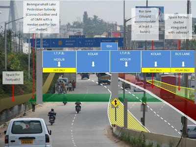
A solution for eastbound OMR/ORR lanes
Below is my visualization of SB's suggestion for a pedestrian subway combined with a "median bus-stop" (for Eastward bound lanes).
 |
| From Praja_posts |
pic courtesy: CKannan
It seems (from my rendering of the picture atleast) that there is adequate space for a 'median bus-stop' for buses intending to use the Cable-stayed bridge. For buses intending to go to Whitefield, a curbside bus bay can easily be added beyond the Cable-stayed bridge entry point. A simple footpath can integrate the two. Also added, lane specific signage, something other forum topics have discussed in the past. So here's what's involved:
- Lane remarking
- Additional overhead signs- maybe two more in addtion to the one I've added, one each on the Benniganahalli overpass and one on OMR just after the RUB.
- 2 policemen for about a month; One to shepherd buses in to their exclusive lane and another to prevent them from stopping at the base of the bridge.
- A new subway and some added footpaths (space for both of which exists). With the use of magic box(es) the subway should take just a couple of days (maybe one weekend).
Admittedly, this is just the tip of proverbial iceberg. What lies ahead is convincing the NHAI, SWR, BDA, BBMP and BMTC that they need to do something about the situation now. Together.
transmogrifier
PS: CK, thanks for the pics, finally gave me the chance to sketch out some of my thoughts.
KR Puram Railway Station Jn Update
Finally BDA and Traffic Police seem to have woken up to the traffic problem at KR Puram junction (opposite railway station). BDA is proposing to widen the roads leading to the junction (on either side of the cable bridge).
The main hurdle to the project is the narrow junction opposite the railway station. Though there is ample space to widen the road, the land is owned by the Railways and they are refusing to give up the land.
However BDA is proposing an alternative. They plan to acquire govt land in the vicinity of the railway station and give this to the railways in exchange for the land next to the road. This proposal was submitted to SW Railways more than 3 weeks back. The Traffic police represented by Mr Praveen Sood, was also part of this meeting called by BDA.
SW Railways had started the construction of ticket counters in this land next to the road. They had responded positively by stopping any further construction. But nothing has moved since then. This is a high traffic density junction. The stretch is part of the ring road and also links Hosur Main road to Bellary road and Tumkur road (NH4 and NH7) and is also a vital link between the city and Whitefield area.
Even by the most optimistic estimates a person traveling to Whitefield spends on an average half an hour’s time here every day. Even if half of the workforce working in Whitefield take this route (the only other route to Whitefield is the old airport road) that is 20,000 people (only from the Whitefield area). If the junction is decongested, the travel time will reduce to 10 mins (5mins each way), that’s a saving of 20 mins. That is 20000 x 20 mins – around 6667 man hours saved per day!!!.
Industries (Devesh sir are you listening?) and Praja should pressurize SW Railways to accept this proposal. How about some petitions to SW Railways? Praja members with contacts in Railways, please try to find out the status.
The other major problem in this region – Benganahalli railway underpass, God save the people who have to pass through this. Oh by the way the Railways have put up some ads on the railway bridge. It is like the Railways telling us – you better stop, see these ads and then proceed - and repeat these steps atleast 5-6 times everytimes you have to pass through this underpass.
KR Puram bridge area - Good going traffic police!
 I have waited to post this, 3 weeks to be precise because I want. After after our street photography adventure at OMR/ORR junction, I have been noticing a few changes at this junction of junctions.
- The pedestrian walk signal which was not working (the traffic cops we had met that day had confirmed this) is now operational. See the photo, notice the signal in 'red' and vehicles waiting for peds to cross. Mind you, this as at 9.05 am on a weekday, peak hour at this location.
- Remember how we noticed that the big bus stand area right after HP petrol bunk was simply not getting used? Now, the police makes sure all buses enter that bus stand and not block traffic on outer ring road.
- Next, they have clearly marked (fresh white paint) a few zebra crossings in the area. I notice at least three of these, and at least one of the new zebra points also has a newly installed flashing warning light. Sorry, couldn't manage photos on this one.
- Despite the new zebra points, and the operating signal, pedestrians will be pedestrians. Some of them still cross this 10 lane wide road at arbitrary points. Can't do much about them.
Since I don't cross the area from Benniganahalli side coming in to Whitefield, I am not aware of what they are doing or have done to smoothen flow on that side, but changes on the tin factory side are well appreciated.
Good going Traffic Police. Drops make an ocean, and we need many such drops of initiatives.
KR Puram meeting - pics
 7 of us showed up, 6 in one batch and 1 on his own (came to know later) for this event. Met Kannan for the first time and speaking to him made it clear that he has given detailed thoughts to possible solutions for this chaos. He will soon be scanning and posting his sketches here.
We ended up spending most of our time on the Benniganahalli lake side of this chaotic place, so not enough pics from the more popular traffic chokepoint which happens to be right under the bridge.
I have been hoping to find some quality time to call out few points right on top of these pics, but for lack of time, its better to upload some random ones from the pack, and do any paints later.
Things I noted:
- There is enough space for a two lane island bus stand which could be used by buses that will stay on OMR (towards Kolar), or on ORR (towards Hennur)
- There is a huge bus bay right after HP Petrol Bunk, but is just not used!!
- There is a pedestrian operated signal installed, but has not been working for many months now.
- The island bus stand (opposite from HP Petrol bunk) is very popular. the buses on this side (near ptrol bunk) have lot more space to play with.
- Saw two close shaves right when we were watching around, have even captured one on camera. This on a Saturday late morning?
- Three traffic cops were parked, right near the temple, in "stand and deliver" mode, doing nothing more than paper checking from what I could see. There was one more traffic cop, directing traffic near the island bus stand. Anyway, they too moaned about pedestrian problems and said that the place needs a ped subway.
- Vehicles, esp autos and cabs go in all directions under the bridge, even when one traffic cop was standing. Basically, there are self create and un-written rules that keep everyone happy - cabs/autos carrying traffic out of Railway Station, vehicles going in and out from Kagdaspura side.
- Less said about pedestrian markings/pavements/signs/facilities the better. But its a two way street - peds are all over the place (their fault too), and there are no clear signs to guide them as well. One traffic cop I spoke to was very vocal about this (pedestrians on the loose!).
Some more tidbits:
- That pedestrian operated signal has now been working for last few days. Perhaps just a coincidence :) But in any case, nobody respects the newly operating signal, red or green, vehicles just go and go.
- One of the traffic cops told us that K R Puram police station maintains stats on accidents at this hotpost. (Kannan told us that 3 kids have died crossing the road under the bridge in last 8 months). Just getting and publicizing those stats should help.
- Manjari suggested that we organize "Praja caps" so that it will be easier for us to find each other at Praja events. Great idea! She has volunteered to help organize the caps for us, eagerly looking forward to wearing them.
I think we should do more such field events, but need to organize and publicize better. Being on the street (and not merely seeing things from our bikes and cars) provides better picture of things.
Last but not the least, next steps?
- Kannan has not approached any authorities yet. We should take his and our thoughts to Traffic Police. Let us approach Mr Sood, as well as BDA when we think we are ready.
- Apparently, railways and BDA have agreed on a solution to get more road width for ORR under the bridge (unsure). Should check on this and track whatever they may have planned.
ORR choking near KR Puram station - one reason
Speaking of KRPuram shouldnt this entire length be only 2 lanes wide? Why are they allowing the use of the entire pancreatic bulge before the chicken neck? There should only be as many lanes as allowable for the entire stretch. So what do the "engineers" in the BBMP think when they lay asphalt? Do they know their profession has a meaning?
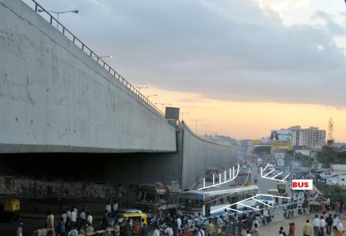
The adventurous bus stands - K R Puram
 There are a few of these special bus stands these days that exist right before a flyover or an underpass. Just as the road forks and grade separation begins, you find some crowd. Buses usually stops to block traffic heading towards the underpass or flyover. And pedestrians either have to run across flowing traffic, or wait in the middle of traffic to catch buses. Needless to say, you get a lot of 'almost' hit-and-run and screeching halt situations.
The joys of crossing a road
 The pedestrian chaos at ORR-Old Madras Road interchange can'tt be stated in words, so I tried this video last week (find it below). The place is a live example of collaboration, lack of it rather, between multiple sarkaari bodies. Bring this up with a babu in Bangalore and instead of ideas or initiatives, you will get stories of how things can only fall between NHAI, Railways, BDA, and the Traffic Police but not improve. Oh yeah, the job of taking initiatives is best left to the citizens.
Some bonus things for you to note in the video , that is if you have never been to this side of the city:
- Notice how call center cabs create the jam as you hit the bridge from Whitefield side. Notice the Unisys cab picking up passengers in this video.
- You wont miss the flood of pedestrians crossing over to catch the bus. This is 9:00 am, and there is no ped-xing signal, or cop to help them cross.
- Enter the OMR/ORR road merge area next to HP bunk. The place isn't as crowded in the video, but notice the folks walking around freely everywhere on the road. Why? The buses stop everywhere.
- Last, towards the end of the video, notice the call center cab picking up passengers at the foot of the flyover.
Some photos as well of this buzzing area. In one of these, notice a traffic signal on Old Madras Road right at the foot of the cable bridge. Haven't seen it working recently, and not sure of its purpose - to let people pedestrians cross, or to control the ORR/OMR merge?
If you read this post till here, would you be game to join in for a "cross the Old Madras Road" event at this spot!? 10-15 of us will experience the joys of being pedestrian first hand, and take some pictures to mail to ABIDE, BDA, Traffic Police etc.
Data from Bangalore Traffic Police
A gyan page to hold together posts that carry statistics and data received from Bangalore Traffic Police. Bangalore Traffic Police collects and maintains detailed statistics on
- Count of registered vehicles in the city (possibly from RTO)
- Traffic violations, by type of violations across types of vehicles
- Fine collected, by types of traffic violations
- Accidents reported, by type of vehicle reported on
- Traffic violations recored, by area (police stations)
And possibly more. Users with appropriate permissoins to "outline" Praja posts are requested to put Bangalore traffic stats posts under this Gyan page.
Motorcycles kill more than BMTC buses?
An interesting stat in the data sets from Traffic police - despite all the negative talk about BMTC drivers (tabloids love it), motor cycles accidents result in more deaths on city roads than BMTC buses. Further, tractors cause more deaths on city roads than taxis and maxi cabs combined. So much for the yellow plate trash talk :)
Accident cases reported, till July in 2010:
|
Sl. No. |
Type of Vehicle |
Fatal Cases |
Non-Fatal |
Damage |
Total Cases |
||
|
Cases |
Killed |
Cases |
Injured |
||||
|
1 |
BMTC Bus |
57 |
57 |
183 |
217 |
35 |
275 |
|
2 |
KSRTC Bus |
8 |
8 |
27 |
36 |
9 |
44 |
|
3 |
Factory Bus |
1 |
1 |
5 |
5 |
6 |
12 |
|
4 |
Private Bus |
13 |
13 |
44 |
51 |
37 |
94 |
|
5 |
Lorry |
83 |
100 |
157 |
196 |
189 |
429 |
|
6 |
Car |
71 |
76 |
752 |
932 |
251 |
1074 |
|
7 |
Taxi |
3 |
3 |
29 |
40 |
16 |
48 |
|
8 |
Jeep |
3 |
3 |
23 |
34 |
8 |
34 |
|
9 |
Auto Rickshaw |
13 |
13 |
219 |
259 |
23 |
255 |
|
10 |
Motor Cycle |
76 |
79 |
603 |
666 |
47 |
726 |
|
11 |
Scooter |
8 |
8 |
98 |
110 |
9 |
115 |
|
12 |
Moped |
3 |
3 |
27 |
28 |
2 |
32 |
|
13 |
Tempo |
37 |
39 |
169 |
233 |
93 |
299 |
|
14 |
Van |
4 |
4 |
48 |
57 |
16 |
68 |
|
15 |
Maxi Cab |
11 |
11 |
44 |
61 |
30 |
85 |
|
16 |
Un-Known Vehicle |
43 |
43 |
43 |
56 |
3 |
89 |
|
17 |
Military Vehicle |
3 |
3 |
0 |
1 |
0 |
3 |
|
18 |
Tractor |
15 |
15 |
19 |
24 |
7 |
41 |
|
19 |
Tanker |
9 |
9 |
19 |
28 |
5 |
33 |
|
20 |
Cycle |
0 |
0 |
0 |
0 |
0 |
0 |
|
21 |
Jataka |
0 |
0 |
0 |
0 |
0 |
0 |
|
22 |
Bullock Cart |
0 |
0 |
0 |
0 |
0 |
0 |
|
23 |
Others |
4 |
5 |
31 |
57 |
16 |
51 |
|
TOTAL |
465 |
493 |
2540 |
3091 |
802 |
3807 |
|
Same holds for 2009 as well, so 2010 has been no aberration
Accident cases reported, full year 2009, source: Traffic Police
|
Sl. No. |
Type of Vehicle |
Fatal Cases |
Non-Fatal |
Damage |
Total Cases |
||
|
Cases |
Killed |
Cases |
Injured |
||||
|
1 |
BMTC Bus |
77 |
82 |
280 |
359 |
77 |
434 |
|
2 |
KSRTC Bus |
14 |
14 |
49 |
58 |
20 |
83 |
|
3 |
Factory Bus |
3 |
3 |
6 |
7 |
3 |
12 |
|
4 |
Private Bus |
31 |
31 |
102 |
144 |
52 |
185 |
|
5 |
Lorry |
100 |
107 |
300 |
392 |
296 |
696 |
|
6 |
Car |
112 |
116 |
1330 |
1619 |
483 |
1925 |
|
7 |
Taxi |
10 |
10 |
59 |
77 |
30 |
99 |
|
8 |
Jeep |
5 |
5 |
54 |
65 |
8 |
67 |
|
9 |
Auto Rickshaw |
31 |
31 |
425 |
505 |
43 |
499 |
|
10 |
Motor Cycle |
123 |
124 |
1208 |
1343 |
97 |
1428 |
|
11 |
Scooter |
14 |
15 |
191 |
213 |
11 |
216 |
|
12 |
Moped |
6 |
6 |
40 |
43 |
1 |
47 |
|
13 |
Tempo |
67 |
71 |
298 |
377 |
170 |
535 |
|
14 |
Van |
6 |
6 |
111 |
139 |
33 |
150 |
|
15 |
Maxi Cab |
14 |
15 |
75 |
128 |
28 |
117 |
|
16 |
Un-Known Vehicle |
90 |
90 |
63 |
70 |
10 |
163 |
|
17 |
Military Vehicle |
2 |
2 |
5 |
4 |
7 |
14 |
|
18 |
Tractor |
10 |
10 |
41 |
46 |
9 |
60 |
|
19 |
Tanker |
13 |
13 |
20 |
22 |
9 |
42 |
|
20 |
Cycle |
0 |
0 |
2 |
2 |
0 |
2 |
|
21 |
Jataka |
0 |
0 |
0 |
0 |
0 |
0 |
|
22 |
Bullock Cart |
0 |
0 |
0 |
0 |
0 |
0 |
|
23 |
Others |
9 |
10 |
50 |
55 |
42 |
101 |
|
TOTAL |
737 |
761 |
4709 |
5668 |
1429 |
6875 |
|
Statistically speaking, lorries seem to be most dangerous - notice the high death to injury ratio (107/390). Other stat that catches the eye is - Motorcycles have higher death to total cases reported ratio than cars. 124/1428 vs 116/1925.
Number and Type of Violations
Data on traffic violations, by type - comparative statement: M.V. ACT Cases booked for years 2006 TO 2010 in Bangalore City:
|
# |
Type of Offences |
2006 |
2007 |
2008 |
2009 |
2010 Till 31/07 |
|
1 |
Dangerous Driving |
105009 |
86952 |
86436 |
55567 |
31665 |
|
2 |
Over Speeding |
4567 |
3666 |
31001 |
63677 |
43272 |
|
3 |
Over Loading |
22276 |
15398 |
13617 |
14413 |
9180 |
|
4 |
Drunken Driving |
27264 |
27644 |
30593 |
38665 |
40683 |
|
5 |
Refuse to go for Hire |
17379 |
12455 |
14139 |
21820 |
21082 |
|
6 |
Demanding Excess Fare |
7777 |
6578 |
8639 |
11686 |
11156 |
|
7 |
A/R Display Card |
726 |
1607 |
623 |
1626 |
918 |
|
8 |
Defective Fare Meter |
40 |
56 |
63 |
39 |
100 |
|
9 |
Defective Silencer |
21949 |
10482 |
12814 |
12005 |
14206 |
|
10 |
Emitting Block Smoke |
19149 |
8112 |
10966 |
215 |
674 |
|
11 |
Shrill Horn |
26356 |
28333 |
26568 |
13286 |
15827 |
|
12 |
Without Permit |
3638 |
3678 |
2772 |
2314 |
1100 |
|
13 |
Without D.L.. |
78758 |
55937 |
61102 |
40791 |
26068 |
|
14 |
Jumping Traffic Signal |
180271 |
143844 |
288705 |
558420 |
344762 |
|
15 |
Wrong Parking |
256956 |
217593 |
239639 |
377971 |
271548 |
|
16 |
Cutting Yellow Lane |
41825 |
17588 |
64548 |
117197 |
122386 |
|
17 |
Defective Registration No Plate |
37848 |
32460 |
49945 |
43188 |
31976 |
|
18 |
No Entry |
111554 |
85291 |
124399 |
282111 |
265611 |
|
19 |
HTV Prohibited |
51380 |
34227 |
50392 |
55441 |
48742 |
|
20 |
Without Uniform |
43650 |
27094 |
49897 |
62571 |
41514 |
|
21 |
Without I.C. |
19861 |
15716 |
24497 |
8834 |
3697 |
|
22 |
Without F.C. |
156 |
233 |
317 |
286 |
112 |
|
23 |
Defective Head Light |
26347 |
19918 |
20489 |
20348 |
11871 |
|
24 |
Defective Tail Light |
1269 |
498 |
770 |
1019 |
553 |
|
25 |
Not Produce Documents |
50803 |
34337 |
47490 |
22460 |
13877 |
|
26 |
Over taking by left |
39145 |
29844 |
43199 |
25639 |
5948 |
|
27 |
Mobile Phone |
29496 |
19372 |
40282 |
64297 |
51003 |
|
28 |
Safety Belt |
92 |
636 |
636 |
900 |
1119 |
|
29 |
Without Helmet |
59297 |
237998 |
199862 |
230769 |
154734 |
|
30 |
Others |
233971 |
162509 |
240190 |
366084 |
276059 |
|
TOTAL |
1518809 |
1340056 |
1784590 |
2513639 |
1861443 |
|
Number of vehicles registered in Bangalore
Number of Motor Vehicles registered & kept for use in Bangalore city, 1976 to 2009 (UPTO 31.12.2009)
|
YEAR |
TWO WHEELERS |
THREE WHEELERS |
CARS |
JEEPS |
TAXIES |
BUSES |
TRUCKS |
TRACTORS |
TRAILERS |
MAXI CAB |
OTHERS |
TOTAL |
|
1976 |
62199 |
8699 |
21760 |
2048 |
1045 |
3487 |
6081 |
1419 |
1121 |
* |
578 |
108437 |
|
1977 |
78974 |
10132 |
27810 |
2986 |
964 |
3685 |
6516 |
1454 |
1164 |
* |
641 |
134326 |
|
1978 |
87753 |
10608 |
29302 |
3179 |
999 |
4000 |
6920 |
1531 |
1236 |
* |
781 |
146309 |
|
1979 |
97110 |
10726 |
30245 |
3396 |
1034 |
4301 |
7575 |
1897 |
1680 |
* |
505 |
158469 |
|
1980 |
111750 |
10044 |
31738 |
3554 |
1120 |
4671 |
8236 |
1929 |
1734 |
* |
549 |
175325 |
|
1981 |
125600 |
10355 |
32429 |
3570 |
1171 |
5090 |
8545 |
1781 |
1637 |
* |
475 |
190653 |
|
1982 |
135586 |
11063 |
33506 |
3726 |
1276 |
5507 |
10020 |
1823 |
1678 |
* |
514 |
204699 |
|
1983 |
162206 |
11880 |
36064 |
4043 |
1607 |
5931 |
10686 |
1510 |
1361 |
* |
757 |
236045 |
|
1984 |
189619 |
11348 |
47787 |
4995 |
2027 |
6155 |
11106 |
1493 |
1444 |
* |
1676 |
277650 |
|
1985 |
216234 |
10446 |
53150 |
4914 |
1756 |
5168 |
11532 |
755 |
671 |
* |
1963 |
306589 |
|
1986 |
236726 |
10524 |
54885 |
5122 |
1717 |
5704 |
11366 |
496 |
446 |
* |
2269 |
329255 |
|
1987 |
301877 |
12439 |
64703 |
5741 |
2027 |
6575 |
13013 |
693 |
589 |
* |
3127 |
410784 |
|
1988 |
343738 |
15513 |
65916 |
5966 |
2089 |
4247 |
15229 |
893 |
789 |
* |
6500 |
460880 |
|
1989 |
401811 |
15591 |
71078 |
5823 |
2218 |
4215 |
16467 |
853 |
762 |
* |
5443 |
524261 |
|
1990 |
458860 |
17379 |
82205 |
6376 |
2511 |
4516 |
19149 |
1993 |
1723 |
* |
3574 |
598286 |
|
1991 |
502707 |
23350 |
91883 |
6819 |
2783 |
4775 |
21758 |
2217 |
1915 |
* |
3941 |
662148 |
|
1992 |
522617 |
24748 |
92095 |
4322 |
2865 |
6146 |
26687 |
2272 |
1922 |
* |
8861 |
692535 |
|
1993 |
522617 |
24748 |
92095 |
4322 |
2659 |
10139 |
26687 |
2272 |
1922 |
* |
9874 |
697335 |
|
1994 |
577710 |
33338 |
103872 |
4784 |
3198 |
10301 |
25494 |
3288 |
3072 |
709 |
8138 |
773904 |
|
1995 |
648994 |
37438 |
116991 |
5698 |
3195 |
11262 |
28785 |
3719 |
2512 |
2007 |
10058 |
870659 |
|
1996 |
736798 |
46674 |
133540 |
6245 |
4239 |
12145 |
31238 |
4277 |
3778 |
2464 |
11852 |
993250 |
|
1997 |
817273 |
54124 |
148437 |
6579 |
4786 |
15165 |
33303 |
4936 |
4523 |
2889 |
12862 |
1104877 |
|
1998 |
892674 |
54689 |
160869 |
6676 |
5144 |
15832 |
34708 |
5357 |
4822 |
3195 |
12474 |
1196440 |
|
1999 |
971518 |
57304 |
178495 |
6800 |
5523 |
17701 |
36522 |
5713 |
5143 |
3698 |
17026 |
1305443 |
|
2000 |
1067430 |
61424 |
201052 |
6827 |
6299 |
20656 |
41887 |
6158 |
5544 |
4238 |
16542 |
1438057 |
|
2001 |
1162111 |
64001 |
221508 |
6934 |
7062 |
22841 |
47683 |
6743 |
6100 |
4723 |
16436 |
1566142 |
|
2002 |
1292228 |
67778 |
245893 |
7091 |
7974 |
24989 |
53424 |
7681 |
6873 |
5270 |
19728 |
1738929 |
|
2003 |
1419396 |
72107 |
269648 |
7434 |
9444 |
28262 |
59150 |
8723 |
7359 |
7219 |
23599 |
1912341 |
|
2004 |
1586397 |
74357 |
314931 |
7991 |
13132 |
34271 |
68186 |
10481 |
9456 |
10458 |
27820 |
2157480 |
|
2005 |
1811361 |
80432 |
359580 |
11012 |
16484 |
36888 |
84571 |
11994 |
11023 |
12659 |
31266 |
2467270 |
|
2006 |
2074306 |
90934 |
426394 |
7587 |
20025 |
39162 |
91699 |
18564 |
10699 |
16100 |
45682 |
2841152 |
|
2007 |
2232271 |
95029 |
490982 |
7609 |
28223 |
48159 |
109761 |
19646 |
11670 |
18017 |
45197 |
3106564 |
|
2008 |
2263552 |
95859 |
515109 |
7272 |
30940 |
48605 |
119051 |
20151 |
11779 |
18653 |
53668 |
3184639 |
|
2009 |
2607536 |
105630 |
606427 |
8188 |
31879 |
42164 |
129312 |
20353 |
12133 |
20903 |
68843 |
3653368 |