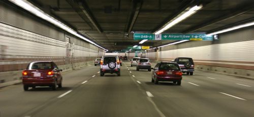
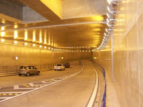
Rethinking road-widening - Tunnels?

One of the core infrastructural issues we are facing is an inability of our arterial roads and highways to provide rapid cross-town access. Globally, city and highway planners recognize and create different infrastructure for highways and city roads. See Dr. Joglekar’s posts here for a succinct description of this problem plaguing most Indian cities. A simple schematic (full size image here)and an inventory of city highways reveals the problem.
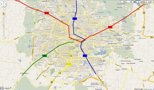
Thru Highways:
- NH7 (in blue)
- NH4 (in red)
Terminal Highways:
- NH-209 (in yellow)
- SH-17 (in green)
While the ORR and the planned PRR attempt to relieve through-traffic, these highways ironically remain some of the fastest cross-town routes. Recognizing this, infrastructural planners have expanded/widened roads leading into the city where land was available and have built (BETL, Mysore Rd flyover), are building (Nelamangala expressway) or planning to build (Balabrooie-Hebbal) long flyovers to ‘jump’ the bottlenecks. As we all know though, these just move the bottlenecks. And so, the ever-unpopular (and time-consuming) appropriation of massive amounts of land and road-widening is being touted as the panacea. There might be another way though.
An alternative
One option might involve reconnecting NH-4 and NH-7 using a belowground access-controlled (NOT signal-free) highway that cuts through the city and ensuring that NH-209 and SH-17 don’t ‘dump’ traffic in the middle of the city (full size image here).
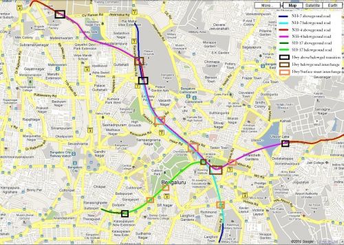
Specifically:
- Travelling south, NH-7 would move completely off the existing Bellary Rd after the Mekhri circle underpass moving onto Palace ground property (that might be available). At Cauvery theatre, it would join an emerging NH-4 and then ‘dive’ underground just before Palace Road ‘emerging’ near (or after) the Military school on Hosur Road.
- Traveling east, NH-4 would go underground near the IISc Gymkhana ground (potentially before the MS Ramaiah Rd intersection). It would emerge near Cauvery theatre (on Bellary Rd) and join NH-7. After ‘re-submerging’ near Palace Rd, it would travel along with NH-7 branching off (belowground) to emerge near the Bhaskaran Rd/Kensington Rd intersection
- Traveling north, SH-17 would go belowground at the foot of the Sirsi Circle flyover and join NH-4/NH-7 underground.
- NH-209 would terminate at ORR leaving users the option of using SH-17 or NH-7 for a cross-town commute.
The project would function best if expressway design standards are consistently adhered to. All project roads should maintain a constant width (preferably 4 lanes + 2 emergency lanes) widening to 6 lanes only in sections where highways combine (e.g. NH-4 and NH-7). A limited number of surface exits could enable rapid access to different points in the city (K.G. Road, Kanteerava stadium, Millers Road/Vidhana Souda, HSRL terminal/M.G. Rd, Kamaraj Rd, Richmond Rd etc). Further appropriately designed interchanges (dark brown squares in pic) would be required to connect highways underground.
Pros, cons and disclaimers:
- Cost: Similar projects across the world have cost anything from Rs 280 crore (for Sydney’s 2-lane Cross City tunnel to a staggering 66,000 crore (for Boston’s 10-lane Big Dig. However, BBMP’s existing road-widening plan on 6 corridors already calls for an investment of 597 crores.
- Time: Similar projects have taken anything from 2 years (Cross City tunnel) to 22 years (Boston’s Big Dig)
- With adequate planning, inconvenience to road users can be minimized with tunneling work starting in areas where no current roads exist (e.g. Palace Grounds, Ulsoor Lake, SJ Park) emerging onto the surface nearer the completion date. After cross-town connections are complete, exits to surface streets (e.g. K.G. Rd, M.G. Rd) can be added on.
- Other arterial corridors can (in some cases) be redesigned to filter onto ‘reconnected’ highways. For example, Old-Airport Road can be connected to NH-4 using Suranjan Das Road.
- This project would not address existing bottlenecks outside the project area (e.g., the Bennigannahalli bottleneck on Old Madras Rd). However, using a consistent road-width 4 (travel) +2 (emergency) lanes and strict access-control throughout would make the highways effective travel corridors.
- The project does not address surface streets or public transportation. However by reducing current traffic loads on surface streets, roads can be engineered to maintain a consistent (4-6 lane) width, turning refuges and better pedestrian infrastructure. Existing one-ways can be reverted to two-way traffic or provide contra-flow bus lanes.
These ideas are not new to city planners as cities the world over have demonstrated the use of this technology. Will it work for us?
(Image courtesy: Wikipedia)
transmog