
The Srinivagilu village road, which is an ideal link to Intermediate Ring Road (IRR) for S T Bed layout residents heading towards Indiranagar side, is becoming more and more unmotorable. The road, which was concreted a few years back, has got dug up at so many places along the length and breadth, resulting in its reverting to a regular village road, once again.
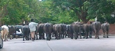
In addition are the features like buffalo herds and their dung trails, cows resting stretched right across the width of the road, fearsome dog packs chasing two-wheelers, vehicles parked overnight (a few almost permanently), all kinds of work-shops with their activities regularly spilling onto the road, and a few individuals even converting sizable patches of the road into their front yards/ storage spaces, etc.
Well, one can't expect total orderliness on such roads (particularly when it is not there even on the main roads). But, the way things are de-generating, one wonders if it would be better to allow only two-wheeler motorised traffic on it, if at all.
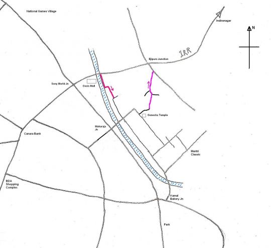
Another option could be to make it a one-way (just the narrow stretch shown in crimson in the picture below), allowing traffic only North-wards (ie towards Ejipura jn). Like-wise, the narrow stretch of the road letting off from the IRR at Naveen Terraces (adjoining the storm water drain, just before Oasis Mall - heading from Indiranagar side, and marked in red in the picture), could also be made a one way, allowing traffic only East-wards (into S T Bed layout).
Whatever, in the long run, I guess we also need to take a call on whether we can have village dis-orderliness amidst city orderliness (assuming that will happen in some future day) making for a merry/ inclusive (?) mix.
Muralidhar Rao


Comments
ST bed layout
ST bed layout [1] looks to be a fairly well developed layout bordering the army portion. Are there any good properties available? What is the current price like? Seeing the buffaloes does give a village look. With all kinds of workshops I wonder who the corporater is and what the ward number is. Can we have this info sir?
As per article 75 which is about 20 years old I think there should be a ward committee in place, which should be meeting periodically. Improvement of the road issue is a fit matter to be discussed in the ward committee. IMHO Murali sir should try to put this up to his ward committee for discussion with the corporater.
In my ward 58 the MLA Raghu's fund has been utilised for similar development work . The Corporator of my ward # 58 is Smt Sumitra Vijaykumar. Mr. Vijaykumar Husband of the The Corporator is the one who does the running around.
I second Murali Sir's
I second Murali Sir's comments here. I take those 2 colored paths everyday, to join the IRR from ST Bed and then while coming back, I take the road near the naveen-terraces to enter ST Bed area.
I agree that if we make those 2 roads one way, it would be great for motorabiity.
And also, I also had another suggestion to make, that we should create a good footpaths on both sides of road for people to walk safely, which is very much needed, and just 1 lane of motorists, it will make this area less congested and safe for pedestriands and other people who are residential alongside those 2 roads.
I have discussed about the footpath near the drainage, near naveen terraces here as well, but its not going further ahead. Mr. Rajendra Babu (President, RWA ST Bed) who claimed to have done a lot of good work for the ST Bed with the help of local corporator and MLA, doesn't seem to give any good attention to this problem. I am not sure why all the footpaths are being reworked still which is not at all going to be used by anyone (who doesn't agree, please take a walk on footpath and show us the video), then why waste money, instead why not do work for footpath near naveen terraces narrow stretch going inside STBed, along side the drain, which make sure that pedestrians are safe while walking there.
Deepak
Not only this
Not only this, but after coming out of this ST Bed stretch to Ejupura signal, all the so called educated motorists take up all the space on that road, which fully blocks any vehicle coming from the other side (from ejipura), sometime BMTC buses comes from there to ST Bed side.
A median is very much needed there, and before that road has to be constructed on the straight road connecting signal, which just slows down all the traffic there at GREEN.
Need to link IRR to ORR
I think the traffic congestion on the narrow road lined with houses and shops, which is the main street of Shini/Srinivagulu village and was never meant for motoring, is really unfair to the residents of the village, which got absorbed into the city without any kind of consultation or planning.
I think it's important to recognise that Koramangala's (and Shini/Srinivagulu village's) traffic woes are going to continue in the present and possibly worsen in the future now that the armed forces have -- deliberately, in my opinion -- chosen to locate their mammoth married staff quarters project on the one part of their vast land holdings on either side of the Intermediate Ring Road that could have provided an escape route by linking the IRR to Sarjapur Road at or near the Agara Lake junction, where it can connect to the Outer Ring Road.
Such a link road should, of course, have been part of the IRR from the beginning and the authorities should have built that into their negotiations with the armed forces for land to build the IRR. It made/makes absolutely no sense to have a ring road empty traffic into a residential area (at least at the Indiranagar end there's the old Airport Rd. to take some of that traffic but at the K'Mangala end it comes right into the heart of the layout). The continuation of the IRR up to Sarjapur Rd. would have enabled motorists and even buses heading to Sarjapur Rd., HSR Layout, Hosur Rd. and south B'lore to avoid going through K'Mangala -- which would have been good for them as well as K'Mangala residents.
It may still be not too late to try and salvage the situation by initiating the action necessary to officially request the armed forces to be magnanimous, public-minded, citizen-friendly, etc., by allowing some kind of link road (even if it can't be as wide as the IRR now) between the IRR and Sarjapur Rd/ORR. An exit somewhere along S.T. Bed Layout/Friends' Colony could be used by those heading towards the 80 Ft. Peripheral Rd. (junction with 7th Cross), K'Mangala 1st Block, etc.
I really think this would benefit not only residents of Koramangala and, of course, ST Bed Layout and Shini/Srinivagulu village but also a much larger/wider section of citizens who use the IRR to get to Sarjapur Rd., Hosur Rd., south B'lore, etc. (not to mention the hapless traffic police trying in vain to do something about the insane level of traffic congestion in K'Mangala).
Ammu
Welcome Smt Ammu
I must admit that I was unable to comprehend your comment without any Google map and paragraphs.
We see some activity on the Koramangala side of Army land, about it’s plan to build some accommodation. No activity is however evident all along the inner ring road as claimed by you.
Why is the inner ring road is called a ring road I fail to understand beacause it is more of a radial road than a ring. The outer ring road is the inner ring road because I believe one more ring road, the outer ring road, is already conceived.
Sorry, I'm not responsible
Sorry, I'm not responsible for the disappearance of my paragraph breaks.
And since I'm new to this forum I didn't know it was necessary to post Google maps along with comments.
The " activity on the Koramangala side of Army land" involves building accommodation for married staff (as the boards along the Intermediate Ring Road state). That part of the Army land forms a kind of triangle, bordered on one side by the IRR and on another by Shini/Srinivagulu Village, Friends' Colony and beyond, which are now considered part of Koramangala).
...which got absorbed into
...which got absorbed into the city without any kind of consultation or planning
Aha! root cause. Even today splattered around BMR are little villages with 10 ft roads nestling between huge apt complexes with 80 ft roads on either side. Apparently the hope is one fine day they can be bulldozed citing bottleneck. Why cant BDA/BMRDA present a comprehensive town plan with identified areas & access roads etc, present it to these people with respect & explain the benefits of the restructuring BEFORE aquiring the areas into the city, instead of trying to retrofit things afterwards when it is really painful?
I am sure BDA/BMRDA will be thinking I wish these politicians told us we are acquiring, before they actually went ahead & did it, instead of leaving us to tend to the ravage afterwards.
Some pics depicting pity, pedestrians & residents most affected
Look at the below pics, I took while going from Smart side to Ejipura signal ( my regular route)
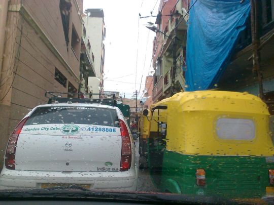
Pic 1:
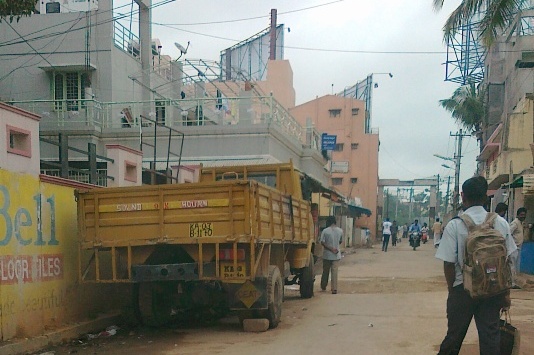
Now see below pic, 4 wheelers are standing in one lane, and auto came from behind and blocked the nearby space as well, now it will block the vehicles coming from other side (there is no restriction there right for 1 way or 2 way).
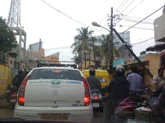
Pic 2:
Another auto came and joined the side lane as well, extending the blockage.
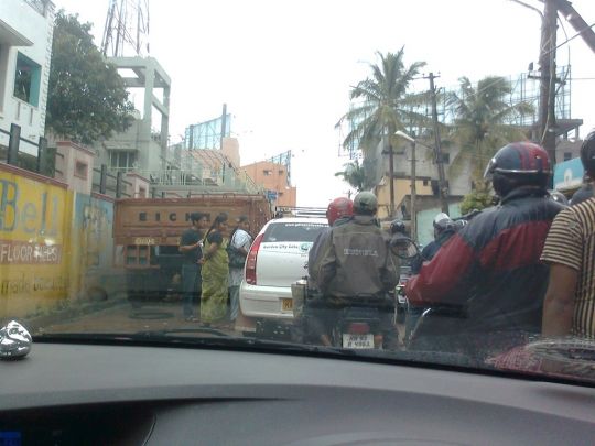
Pic 3:
This photo from the final strech before reaching ejipura signal, autos and 2 wheelers have blocked this total strech in one side, and all the traffic is waiting to get clear because of other side coming vehicles.
Pic 4:
This pic clearly says that such huge trucks are being parked everytime on such a narrow strech and then all the width is being blocked by one side vehicles, and importantly, no space left for pedestrians and residents in that area, I feel pity for them.
So, as I suggested earlier as well that, some kind of planning is very much needed here, you can't have 2 way proper lanes here, either block motorists totally or let them move in particular fashion. First is not a feasible idea, as how will you differentiate between people staying in that area or passer's by. A footpath of approx 2-3 feet total should be constructed on either side, and the space in between should be considered as one-way lane for all, thus giving some disciplinary drive on that strech as well as giving some relief for pedestrians and residents.
Deepak
Some examples from China
Here are some Chinese street examples.
big ticket agenda item
@ Ammu
I think the traffic congestion on the narrow road lined with houses and shops, which is the main street of Shini/Srinivagulu village and was never meant for motoring, is really unfair to the residents of the village, which got absorbed into the city without any kind of consultation or planning.
While that may be true, at least one of the residents on the road very clearly appears to have converted his cattle shed into a car park, and is now rearing his cattle right on the public road (they are there day and night). Like-wise, I wouldn't be too surprised if the buffalo herd owner has also sold of parcels of his land holdings over time, shrinking the land available for tending to his buffalos, and is now merrily using public spaces for the purpose. All kinds of new construction, coming up all over the place, is a testimony to that.
With the dairy industry having established itself fairly well in the country, it is neither practical nor economical nor hygienic to be rearing cattle right in the heart of a city. Perhaps at the time of forming the layout and providing the road linkages itself, the BDA should have given them say a ten year notice period to phase out the activity. In a developing city, there are enough other avenues for livelihood pursuits, even for the unskilled lot, if that be the issue.
Now, while one may have some consideration for the original people of the village, what consideration can you have for the businessmen who are merrily usurping public space for the parking of their vehicles, and almost permanently. The truck bearing regn no 1170 is there in the picture published by me, as well as the one published by Deepak in the above post. In fact, it's there almost always. And, towards evening, a whole lot more line up on either side, reducing the effective road width to just about more than the width of a car, leading to the kind of jam Deepak is talking about.
As stated by me, there is an eminent case for the banning of long term parking of vehicles on the stretch, as also for converting it into a one-way.
The continuation of the IRR up to Sarjapur Rd. would have enabled motorists and even buses heading to Sarjapur Rd., HSR Layout, Hosur Rd. and south B'lore to avoid going through K'Mangala -- which would have been good for them as well as K'Mangala residents.
Yes, this would be a good solution, and for entire Koramangala. It was included in the Master Plan 2015. But, nobody seems to have pursued it so far. Perhaps, that should now become the big ticket agenda item for the RWA federation.
Big ticket agenda item
Dear Murali,
The reason why we can not pursue it at our level is because the proposed road passes through defence area and BDA can not make any plans in areas that are outside its jurisdicvtion - defence land are specifically to be excluded from planning area. The government has taken up the matter with the defence department and unless they get its OK, nothing can happen. The last time I interacted with BDA, I was given to understand that there has been resistance from Defence Ministry because in their Masterplan (called Key Location Plan), this area is meant for building service residential quarters and accompanying infrastructure - a virtual mini township. You can actually see construction activity in the area these days. Therefore we will have to find alternatives to this congestion through ST Bed to IRR.
In fact one of the reasons why we have challenged the masterp[lan in court is that the government planners have not applied their minds while preparing the masterplan and have given this instance as one of the examples.
Regards,
Major Kapur
Something needs to be done, indiscipline adding to more chaos
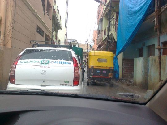
This is my everyday's route to EGL, and when I pass by this road, I strictly think, something needs to be done here on this strech, otherwise day-by-day chaos getting created there.
Look at these 2 photos below -
And,
If everyone follows the one lane, so as to leave the right side for people comin from other side, we can still avoid chaos and long long waiting on this strech, but that doesn't happen. Suddenly, you will see a autowalah come from behind and occupy the space in the right and now you witness a huge chaos and believe me, this half a km strech has taken 25 minutes to drive through.
Secondly, and more importantly, above being told about drivers, bikers, but we are not done yet, what about the residents of this area, they do have right to walk outside their home for regular needs, what about it.
So, i don't think, we can still have 2 way traffic go out there.
Also, we can't stop traffic going through, because how will the residents of this area will drive through, and how will we differentiate between residents and through traffic?
Deepak
we can't stop traffic going
we can't stop traffic going through, because how will the residents of this area will drive through, and how will we differentiate between residents and through traffic?
Simple, Close one end, chose your favourite end :)
Not practical
can't be done, as it will be stil 2-way, and will create other issues.
Those who too that strech must be knowing the reasons.
Deepak
can't be done, as it will be
can't be done, as it will be stil 2-way, and will create other issues.
What are those issues? I just think that road is too convinient for the people who dont live on that road to let go :)
Srinivagilu village road
I have used this road a couple of times. I found it a little narrow for two way traffic. However it is manageble in non peak hours. I have encountered some big SUV's challanging me in my lowly Maruthi 800.
This road is the connecting road to the posh Apartment aglomorations in Lake bed area from Inner ring road.
After all it is a village road away from Main city traffiic. I was told there is a proposal to build a new road conncting IRR to Lake Bed and further to Belandur Lake. This sure will be done as and when Belandur lake is developed properly and fully.
Also one can avoid using this road by using the Koramangala route to access IRR.
Defence area and BDA jurisdiction
The start of the 'Married Accomodation Project' construction in the defence area has probably improved the chances of a decent road - earlier the extent of the defence land was not clearly demarcated. They have now put a boundary and it looks like there is good amount of space for a at least a 40 ft.road. After all, the mini defence township also needs access roads!
With a little planning, this road can be easily extended to 14th Main of HSR Layout. The Sarjapur road junction at Jakkassandra will be a bit of a problem because of a storm water drain, 66KV overhead power line and private propery, but not unsolvable.
Adugodi traffic sub-dvn contacted
Have sent a mail to adugoditrafficbcp@ksp.gov.in, forwarding a link to the debate here, with a request to go through the same and see if the solutions suggested could be implemented.
Will follow up with a call on 22942676/ 9480801822
there's no option now other than to make it a one-way
The above picture is of the village road as of now. The carriage-way width stands reduced to allow for just one four-wheeler to pass at a time, because of the slab level being at least some 4" higher than the carriage-way level. So, if a 4-wheeler comes in the opposite direction while you are trying to go through, everyone is stuck, and for hours together, since you don't even have the option of turning around or reversing. As such, it is now imperative that it's made a one-way, even if just for 3 & 4 wheelers, allowing for traffic flow only northwards (towards Egipura junction), even from the villagers' point of view.
Trust the powers that be pursue it.